

Boondocking in Guadalupe Mountains National Park (Texas)
Purchases made through some links on this page may provide The Detour Effect with commissions (at no extra cost to you). Thank you!
When I spent a few weeks boondocking in Las Cruces, I also ventured into Texas for some day hiking adventures. Driving to the Franklin Mountains near El Paso is an easy day trip from Cruces, but getting to Guadalupe Mountains National Park requires more time and effort as there is not a nearby “gateway town” to base yourself in. I ended up staying there for a full week to make it easier, car camping and working remotely at a dispersed Bureau of Land Management site off of US-62 just before Carlsbad Caverns.

Best Boondocking Near Guadalupe Mountains National Park
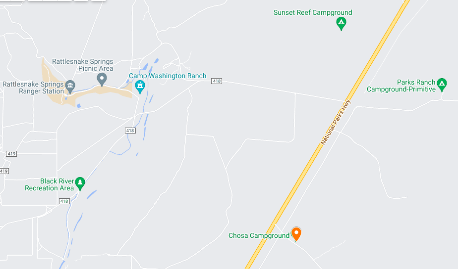
To find free dispersed campsites near the Guadalupe Mountains, I searched using my trusty resource The Dyrt. I found a list of 10 possible camping spots. While Mile 10 and Sunset Reef also look like great options, ultimately I chose Chosa Campground. It was extremely easy to find since there is a clear turnoff from the main road. That said, there is not a sign, so be sure to save the coordinates on an offline map.

When I wasn’t hiking on my days off, I was working remotely from my car using a Verizon MiFi Hotspot. You may be surprised to hear that I got great signal at this campsite! I was able to work without a problem. I used my Jackery Power Station to recharge my laptop with solar panels periodically, which is easy to do in such a wide open space. There is no shade anywhere at Chosa Campground.
There are not any amenities here, so it’s truly dry camping. Come prepared with everything you need. You’ll also want to be ready for variable weather. When I was there in March, I had mostly gorgeous sunny days, but we also had a day where it snowed for hours and was freezing. Another day it was so windy that some kids trying to pitch their tent were putting on a full comedy show for the entire campground.
The site is near the border of Texas and New Mexico, so you’ll be driving back and forth between the two states. The nearest services are at Whites City, the town that welcomes you to Carlsbad Caverns. There is a gas station, a restaurant, and a convenience store with a pretty good selection of easy foods to tide you over while camping. So while the campsite has no amenities and feels somewhat remote, take solace in the fact that essentials are never far away. If you live in your vehicle, note that there are gyms to shower at in Carlsbad (the actual city, not the caverns).
Depending on the day there could be a good amount of other campers, but it didn’t get rowdy when I was there. Having a few other people around actually made me feel safer. If you are looking for ultimate solitude, you might choose one of the other sites on The Dyrt‘s list. There are a handful close to Chosa. I noticed cars and RVs parked at these while I was driving up and down US-62. You could always stay at a developed Park Service campground as well, but there is a price. Boondocking near Guadalupe Mountains is a convenient and painless way to save money.

Camping is free and allowed for up to 14 days at Bureau of Land Management sites. After 14 days you’d need to move along and choose a different site.
Sign up for a 7-day free trial of The Dyrt PRO to find both paid and free campsites; PRO allows offline access, plus more advanced search features and map layers.
Best Day Hikes in Guadalupe Mountains National Park
I didn’t get to try every single hiking trail in the Guadalupe Mountains during my brief trip, but if you’ve only got one weekend in the park, these three day hikes will deliver bang for your buck and are not far from the campsite.
Guadalupe Peak
8.5 miles out-and-back / AllTrails

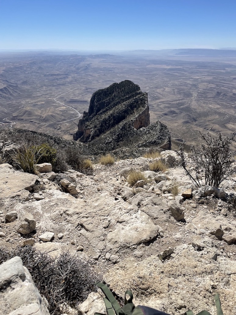
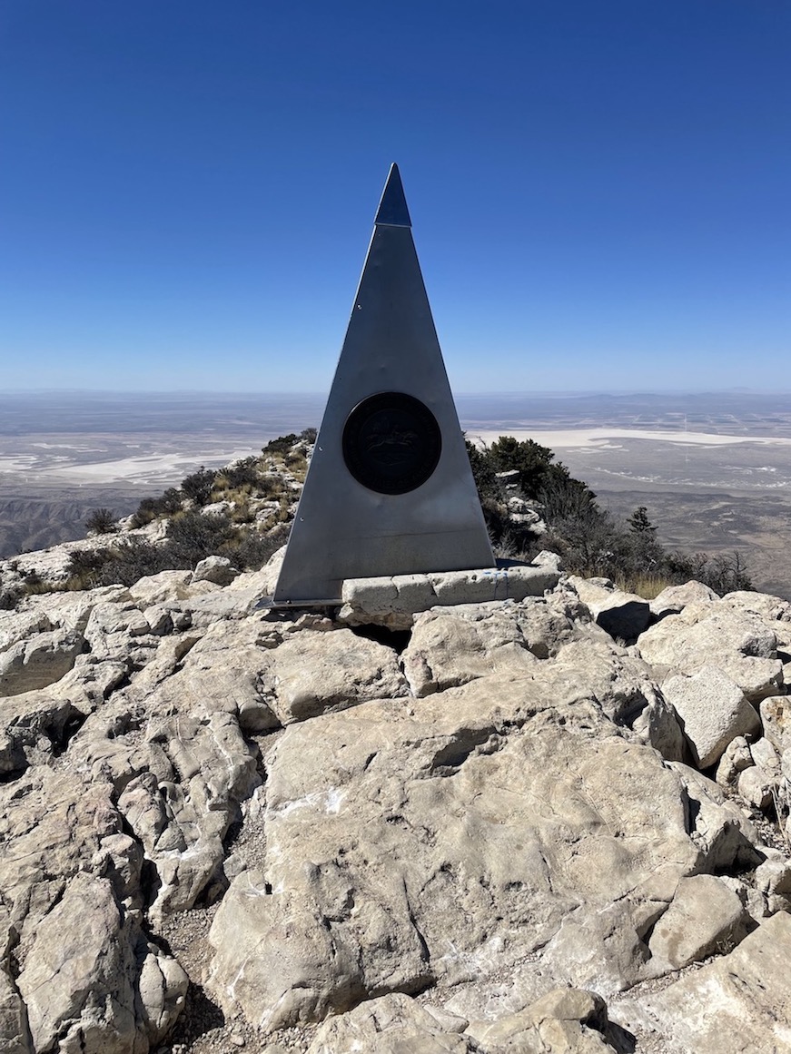


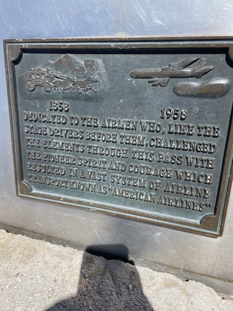


Obviously, the highest natural point is Texas is an item on any peak baggers’ list. At 8,751ft, the summit of Guadalupe Peak brings you expansive views of the Guadalupe Mountains as well as the desolate West Texas desert below.
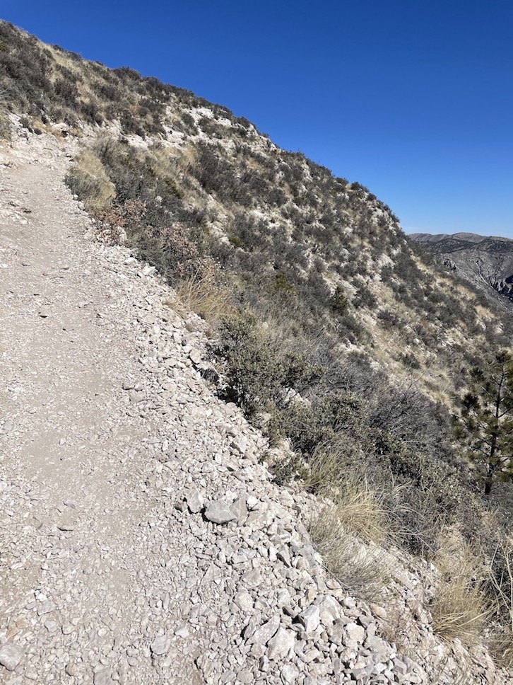
I truly enjoyed this hike because of the rugged terrain. I was out of breath a lot of the way up, but the views were always interesting and periodically you come across what I like to think of as “checkpoints”. When the landscape changes in some way – for instance, you make your way off of switchbacks and into an open meadow, or cross a bridge, or reach the scrambly part of the mountain – each accomplishment is like a new checkpoint to put under your belt to prove you are making progress. This type of variation on a trail encourages me forward.
The final stretch to the summit is the toughest part. For most of the hike you’ve only been testing your lungs and quads, but a few areas of the final rocky ascent might test your guts. I tend to dislike scrambles, so I’m glad I didn’t research this section much before setting out. The word alone may have deterred me, but in practice I didn’t find this part of the trail particularly harrowing. There are definitely moments when you need to get your hands on the rock and plan your footing carefully, but I didn’t fear slipping. Assess yourself as honestly as possible, though. I did come across a family that was doing their best to coax one of their hikers through a section with narrow footing; she was panicking due to fear of heights.
Hunter Peak via Bear Canyon and The Bowl Loop
9 mile lollipop / AllTrails


I liked the final views from Hunter Peak even more than Guadalupe Peak, and I didn’t see a single other soul on this entire hike! That said, there were more points of interest along the trail to Guadalupe Peak.
This hike is a lollipop route. The Bear Canyon Trail is the stick which you’ll repeat out-and-back, and the Bowl Loop is the lollipop. Bear Canyon Trail starts from the same parking lot as the trail to Guadalupe Peak, but you’ll be heading in the opposite direction. Bear Canyon will take you through a dry creek bed and grasslands until you reach the foot of the mountain. From there, it is a constant ascent all the way up to a ridgeline. Keep that ridge in your sight to motivate you forward! On your way there, you’ll weave through a fun gorge full of boulders that will provide a bit of shelter on a windy day. I thought the colors of the rocks here looked like vanilla and chocolate swirl ice cream.
After the boulders, you’ll trudge through switchbacks the rest of the way up to the ridge. I didn’t mind this going up, but on the way back down I realized how loose the rock was. I became a little more cautious about my footing, especially because it was so windy that day. If I got a little nervous, I’d remind myself that once I reach the boulders again, I’m in the clear.
When you reach the ridge, you have finished Bear Canyon Trail and are now embarking on The Bowl Loop, which is smooth sailing. The landscape here reminded me of the San Francisco Peaks in Flagstaff, Arizona.
If you go counterclockwise, you’ll reach Hunter Peak faster. I went clockwise and spent a lot of time in a forest that wasn’t particularly interesting, although it was perfectly pleasant. When I finally got to Hunter Peak I was excited to shimmy up the rocks to the summit marker. From here you will be able to see Guadalupe Peak in the distance.
McKittrick Canyon Trail to Pratt Cabin
5 miles out-and-back / AllTrails


McKittrick Canyon to Pratt Cabin is a totally flat and easy nature trail for all skill levels and a good palate cleanser after doing two more difficult hikes. Or, like me, you could head here first to stretch your legs after however many hours of driving.
The cabin is usually the destination point, but lots of other trails branch off, or you can continue on McKittrick further past the cabin. You’re likely to see a few backpackers heading out on lengthier excursions.
Quintessential desert vegetation will greet you at every turn and you’ll spend some time hiking in and out of a dry creek bed of bright white rocks. Something about this trail really had me pondering the eons of time, probably because the forces of erosion and desertification are modeled so clearly. These must have been ripe dinosaur stomping grounds.
Geologist Wallace Pratt commissioned the stone cabin to be built in the 1930s as a summer home. In 1963, he donated over 5,000 acres of land to the Park Service, including Pratt Cabin, and Guadalupe Mountains National Park came into being in 1972. Pratt Cabin joined the National Register of Historic Places in 1975.
According to the Park Service, “Pratt Cabin is currently used as an interpretive site, commemorating the Pratt family’s residence in the canyon. The east bedroom within the Cabin is used for storage of National Park Service supplies and Cabin materials that are not in use. The grounds around the Cabin and Garage are used as a picnic and rest area for hikers. The Cabin is not open to the public unless a volunteer or ranger is present, nor are there bathroom facilities at the site.”
Boondocking near national parks is fast becoming a favorite road trip and day hiking strategy because it allows me to base myself as close as possible to trailheads, often for free and without requiring backcountry permits. Have you been boondocking in Guadalupe Mountains National Park? Do you have a favorite campground here? What about a favorite hike?
Related:


Pin It:

My dream is to write travel and hiking content full-time. All of my guides and itineraries are free and my travels are self-funded. If you enjoy my site and would like to support, you can donate any amount to my Ko-fi page. Thank you!!
I enjoying reading your hiking adventures. I have hiked those trails a few times. I wouid mention on Guadalupe Peak trail, you can see White Sands in New Mexico, where they set off the first hydrogen bomb. Also on McKitrick Canyon trail, you can take it to a nice picnic area with a nice grotto about a mile past Pratt. Thank you.
Awesome thanks for the suggestions! Wish I had gone all the way to the grotto