

Recap: Solo Trekking Five Trails Across Europe
Purchases made through some links on this page may provide The Detour Effect with commissions (at no extra cost to you). Thank you!
I’ve returned from my month-and-a-half solo trek of five back-to-back trails around Europe, including the West Highland Way, Hadrian’s Wall, The Kerry Way, Tour Du Mont Blanc, and the Slovenian section of the Alpe-Adria Trail. This trip was completely self-planned and self-guided. I didn’t use a trekking company and instead consulted guidebooks, blog posts, maps, and apps. Comparing what actually went down to how I envisioned it has been an interesting exercise. Many detours were carried out, of course, but I’m more surprised how much I didn’t need to deviate, especially in the first half of the trip. I wanted to log the stats to show how travel and hiking will not always go according to plan, and that’s ok and to be expected. What’s important is to make sure you’re adequately prepared so that when those detours become necessary, you have the information and wherewithal to be flexible.
Please research travel insurance to protect your investment if you’re planning a big excursion like this. I would also recommend using an Airalo eSIM for affordable international cell data and a Garmin InReach SOS communication device in case of emergencies.
So how did each trail shake out?
*Don’t feel comfortable solo hiking in unfamiliar places, or prefer someone to take care of the logistics for you? Wildland Trekking offers guided hikes around the world.

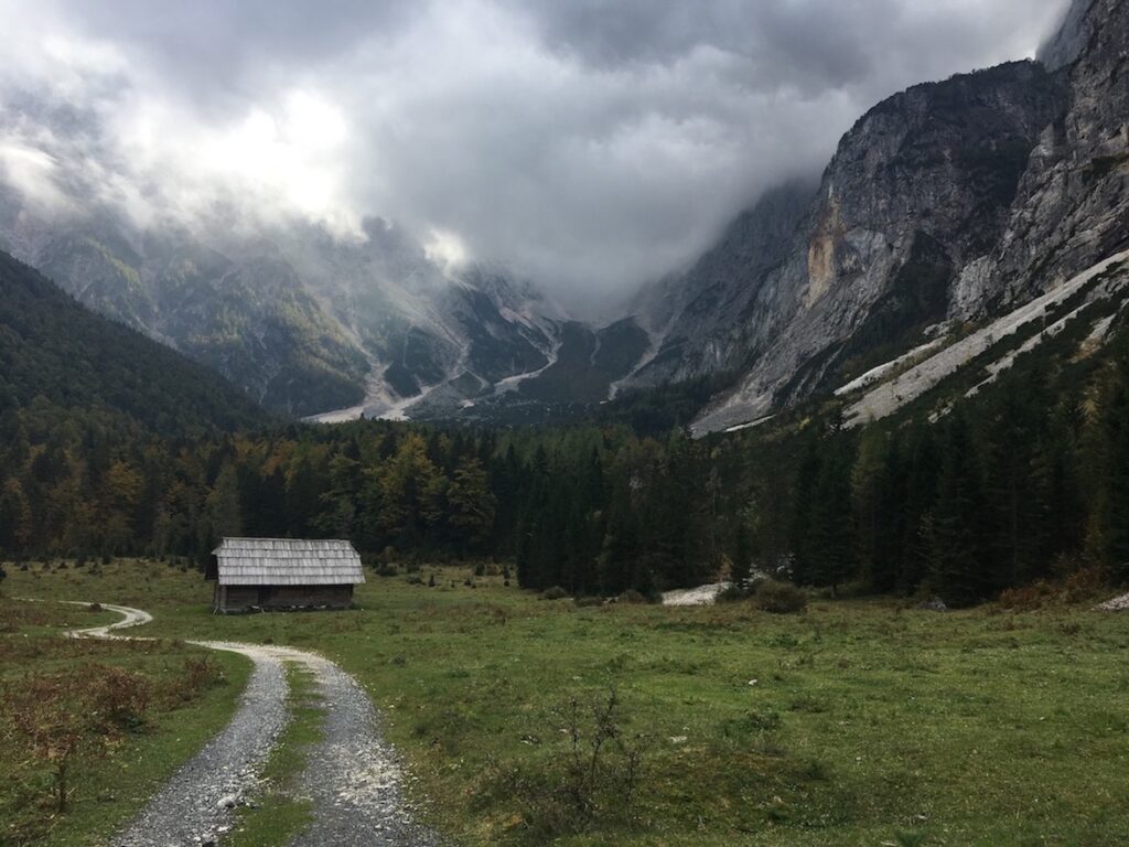
West Highland Way
According to Plan
Days Planned: 8 (September 1-8th)
Days Hiked: 8 (September 1-8th)
Most Helpful Resources:
Mac’s Adventure PDF Guide To Walking the West Highland Way
Scottish Outdoor Access Code website
Loch Lomond & The Trossachs National Park website, “Go wild camping”
Blog Posts:
TMBtent, “Guide to Camping on the West Highland Way”
A Woman Afoot “All You Need to Know about Hiking the West Highland Way”
Apps:
I didn’t use any on this one, but everyone talking about how much they loved their Mac’s Adventure app inspired me to get GAIA for all the upcoming hikes.

Cost Breakdown: Solo Hiking the West Highland Way [2023]
West Highland Way Trail Report:

The West Highland Way went off without a hitch as far as sticking to my planned route and campsites. We had about five days of rain or so, but it was usually on-and-off or light, and because it’s not like the States where we have crazy thunder and lightning storms, I never felt like conditions were too dangerous to hike in. Once you’re wet, you’re wet, so I just embraced it. That said, it could be demoralizing.
The craziest moment weather-wise was probably Day 2 on Conic Hill when intense wind added to the nonstop rain to make for a particularly brutal walk, especially because my pack still felt like a million tons this early on in the trip before I’d gotten rid of a lot of unnecessary gear. After that it seemed to take a lifetime to find my permit camping spot at Lochan Maoil Dhuinne as I trudged through the mud along the shores of Loch Lomond, so Day 2 was the most difficult for me overall, but that camping spot was gorgeous and well worth it. In terms of slogging through rain and muck, the West Highland Way definitely gave me the hardest time (with Ireland coming in second).
The third day, full of tree roots and rocks along the rainy banks of Loch Lomond again, felt like one of those military obstacle courses where they crawl on their stomachs under barbed wire. Every hiker I met after this section spoke of it like it was now relegated to legend – “remember The Worst Day?” – but for some reason I enjoyed it in a ‘Type 2 Fun’ kind of way. Maybe the prior day had properly prepared me.
Day four wore me down again, though. The rain started immediately and because a bridge was down, we had to take a detour through boggy farmland where each step sunk ankle-deep into a waterlogged field. This is when I started cursing Scotland for not coming up with ways to divert the water somehow.
Can’t a country with 265 days of rain a year come together to invent some kind of giant sponge or vacuum? I started to get too cold. But then, miraculously, as we approached the halfway point the storm cleared, the sun came out, and a gorgeous view of the Highlands opened up before me for the second half of the day. It ended up being one of my favorite views of the entire trip, somewhere between Inverarnan and Tyndrum. Every day after this became easier and easier.
I’d say the stage that felt most like the Highlands you envision in your mind would be Day 6 between Bridge of Orchy and Kingshouse, another of my favorites. The next day to Kinlochleven rivals the others in views as you climb up Devil’s Staircase, but descending back down into Kinlochleven annihilated my knees. It just kept going and going, hours of downhill on ankle-rolling rocks. I had many other knee-grinding days over the next month and a half, but I remember this one as the worst.
I think if you happen to be there during a lucky time without any rain, it would be an entirely different experience, with different highs and lows.
Day-by-day recaps of the West Highland Way on Instagram are here, here, here, and here.
Thoughts on the Trail:


There were a ton of other people on the West Highland Way, and in fact I can only recall one or two times I was ever fully alone. I could always spot other parties in the distance ahead or behind me. In some ways I was annoyed by this, but mostly I enjoyed it, to my surprise. I met people from all over the world, and I enjoyed catching back up with different groups to compare notes and find out what their experience had been like since I last saw them. One group called me the trail mascot because different hikers were coming to know me separately, and when they’d meet each other there would always be a conversation of, “have you met Claire yet? With the giant backpack? I wonder how far she made it yesterday and where she camped last night?” Unlike on all the other trails I would go on to do, though, I was not the only camper. There were tons of me. It really added a sense of camaraderie, and witnessing other hikers and campers pressing on encouraged me to do the same. There were some moments when I might have been scared if not for those around me continuing as if the situation were no big deal.
This trail is supportive of camping in ways none of the others are. There’s somewhere to camp at the end of every stage for incredibly cheap or free, plus in Scotland you’re allowed to wildcamp anyway, except in Trossachs National Park where a permit is required (which I applied for and got easily, for £3). Most of the designated campsites have heated drying rooms with circulating air where you can hang your tent to dry out in the morning before you pack it up, and where we all left our sodden hiking boots upon arrival to dry overnight. This was a lifesaver and I came to really appreciate it once it was absent; I don’t recall any drying rooms on any of the other trails. There was usually somewhere to charge your phone and get some kind of breakfast too. With these morning routines I felt ready for the day and not like I still needed to atone for the prior one.
The trail showed us something different every single stage, so I never got bored. In addition to the hills and lochs, we also crossed through primeval forests and explored centuries-old ruins being reclaimed by nature. I actually heard bagpipes floating over the hills at one point, but couldn’t spot the piper. I saw two wild mountain goats with commanding black horns. There’s something that still felt wild here, even with all those other people alongside me. While walking I was often aware of historical context too, because they’ve placed information plaques along the route periodically to educate walkers about the origins of the roads, buildings, or towns we’d pass that day. I imagined myself in those times, daydreaming that I was walking from this village to the next to go to market or learn news of the Rebellion. Because I loved the people and the food I encountered, I also imagined myself living in Scotland today as one of them, venturing into these strange immortal hills whenever it strikes my fancy.
Mileage:
Intended: 96 miles
Completed, according to map: 96 miles
Completed, according to tracker: 103.9 miles

Hadrian’s Wall
Mostly According to Plan
Days Planned: 6 (September 11-16th)
Days Hiked: 5.5 (September 11-16th)
Most Helpful Resources:
National Trails Official Website and Interactive Map
Guidebook:
Walking Hadrian’s Wall Path: National Trail Described West-East and East-West

Blog Posts/Forums:
Go 4 A Walk, “Camping Along Hadrian’s Wall”
Mickledore UK Walking Holiday Specialists, “Walking Hadrian’s Wall – Our Guide”
Apps:
GAIA

Cost Breakdown: Solo Hiking Hadrian’s Wall [2023]
*2023 Update: I’ve just heard the horrible news that a teenager cut down the 300 year old iconic Robin Hood tree at Sycamore Gap in an act of vandalism, I am distraught.
Hadrian’s Wall Trail Report:


I did the trail west to east from Bowness-On-Solway to Newcastle instead of east to west, as I’d heard advice this would keep the weather behind you. When I was planning my trip it didn’t occur to me that this is the time of year that our North American hurricane season is happening, and the western coasts of the United Kingdom receive the after-effects as the storms dissipate across the Atlantic. I learned this pretty fast in Scotland and was glad then to have chosen the west-to-east route in England. I did get one full day of rain, on Day 2 from Carlisle to Banks, which was totally miserable. The first two days were endless, flat, and in my opinion, boring cow and sheep pastures. The first day there were historical sites to see in the towns of Burgh-By-Sands, Drumburgh, and Carlisle which helped break it up, but the second day was just mud and cow poop and not much else. In the rain. It was my least favorite of the trail. The last two days didn’t feature much of interest to me either, but at least I didn’t encounter as many cows. Day 6 is some unattractive city walking as you approach Newcastle, including a stretch along the side of a highway.
The middle two days are incredible. This is where you see the most examples of standing wall parts, milecastles, and Roman Forts. The section of wall that runs along the edge of the Crags is the most impressive; it must have been a feat to build and truly intimidated anyone approaching it from afar, especially as it once stood 15 feet tall and 10 feet wide.
The Roman Forts, like Vindolanda and Birdoswald, transport you to the past, putting the era into perspective so that when you hike along the wall it all makes more sense.
Unfortunately, these museums have incredibly inconvenient opening hours for the typical walker. They’re located at the beginning or end of each stage, so ideally you would wake up early, go see the museum between 7am-9am, then be on the trail by 10am. Or, hike all day long, arrive in town by 4pm or so, and then go visit the museum before turning in for the night. Both options are impossible. They don’t open until 10am and close early around 3pm or 4pm (one of them even closed at 2pm), so it’s difficult to match up your timing in a way that doesn’t interfere with the mileage you’re able to cover that day. One day I waited around for a museum (which was a few miles off-trail) to open at 10am, then wasn’t able to get back on trail until 2pm. I still had 12 miles to cover on the hilliest day of up-and-downs over the Crags. I only made it as far as Housesteads by about 3pm and knew there was no way I’d complete the rest in a timely manner as night fell, so I skipped the last 10 miles by taking the bus to Chollerford. Other than that, the rest of my schedule went just as I’d planned it.
Day-by-day recaps of Hadrian’s Wall on Instagram are here, here, and here.
Thoughts on the Trail:
If I had to plan my Hadrian’s Wall hike again, I would stretch out the middle two days into three or four days to allow time to see all the museums and to fully enjoy the prettiest section of the trail, which is also the most difficult in terms of climbing and descents (unless you do this, I wouldn’t recommend buying the English Heritage Pass. For it to pay for itself, you need to visit a good handful of the museums). For anyone who isn’t a purist and wouldn’t lose sleep over nixing a section rather than thru-hiking it all the way from one coast to the other, the first two days and last two days could maybe even be skipped altogether.

Something unexpected that happened on the Hadrian’s Wall trail had to do with camping conditions. I camped every night except in Carlisle and Newcastle, and it only rained one of those nights, and yet I woke up every single morning with a dripping wet tent. It was the dew. I remember as I left Scotland being excited not to have to worry about trying to dry my tent out each morning before packing it up, but that’s one break I didn’t get in England.
The route runs through towns very often, and I essentially stopped carrying food. I knew this was not a wilderness trail, but it was often enough that I missed the sense of adventure the West Highland Way had given me. I went with it, though, and ended up having a lot of fun visiting all the tea rooms and trying tons of delicious cakes! Although, once again, most of the cafes, bakeries, and tea rooms open late and close early, so don’t count on having breakfast at breakfast time. Developing complaints like this made me feel like a diva, but once you accept that the trail isn’t going to be very wild, you start to teeter back the other way and expect that if this is a city trail, I hope the cities are at least popping?
The first two days I came across a handful of honesty boxes, which was fun. I love trail magic. I met other hikers gathered around them, and in fact met a ton of hikers in general throughout the entire trail. This one is clearly popular and September is still a heavily trafficked time to do it. I did not meet any other campers, only people staying in B&Bs and/or doing baggage transfers.
Mileage:
Intended: 84 miles
Completed, according to map: 74 miles
Completed, according to tracker: 81.2 miles

The Kerry Way
Mostly According to Plan
Days Planned: 9 (September 19-27th)
Days Hiked: 8 (September 19-27th)
Most Helpful Resources:
The Kerry Way official website
Blog Posts:
Tough Soles, “Trail 35: The Kerry Way (Part 1)”
Tough Soles, “Trail 35: The Kerry Way (Part 2)”
Tough Soles, “The Unwritten Rules of Wild Camping”
Apps:
Waymarked Trails App – this thing ruled. I liked it better than GAIA but it’s only for Irish trails.
Note: I’ve now created my own guide. Download my free PDF guide to planning your very own self-guided backpacking trip of The Kerry Way.

Free Download | The Kerry Way: Self-Guided
The Kerry Way Trail Report:
I chose to hike the typical counter-clockwise route of the Kerry Way. The first day was actually the warmest of my entire trip, on any of the five trails, and I was so grateful. The sunny Irish weather stretched into the following 3 days too, with only an interruption of light rain on Day 3 that didn’t bother me much. These were some of my favorite days of my solo backpacking extravaganza overall. I was taken aback by MacGillycuddy’s Reeks, the mountainous region that includes the tallest mountain in Ireland called Carrauntoohil. The sweeping, rolling hills were qualitatively reminiscent of the Scottish Highlands, and perhaps would have been even more so if the weather had turned, but the ominous, mysterious feeling Scotland elicits was replaced with a buoyant lightness. I practically frolicked through them. Everything was as green as one would expect of Ireland and the forests were fairytale-esque, sometimes literally displaying small fairy houses and trinkets (I can see why the myths of Ireland feature few monsters and an abundance of more jovial magical creatures instead). The cliffside you follow along on Day 4, looking out over Dingle Bay, was one of the most dramatic landscape features I’ve ever encountered.
For four days after that, the weather turned and I had nothing but rain as I followed the coast from Cahersiveen to Kenmare. In fact it was bad enough on Day 5 that I had no visibility to aid me along miles of slippery ridgeline, and after giving it a shot for an hour or two I ultimately decided I should turn back and take the bus the rest of the way to Waterville. In retrospect I probably could have pulled it off, but there were a few factors on my mind: 1) my pace was glacial as I tried to climb upwards on slippery bogland and I may have ended up continuing way after dark, when visibility was already bad during the day, 2) the rain was not projected to stop all day, so I knew I’d eventually soak through, 3) I met a girl from Singapore who had twisted her ankle in similar terrain the day before and had to bail on the rest of the hike, 4) a local said to me as I embarked, “if you had any sense you’d turn back now”. It all played on my mind and I couldn’t shake the hesitancy, so I missed about 20 miles of the Kerry Way by skipping this day.
On Day 8 from Sneem to Kenmare I was, for some reason, determined to visit this pancake house that someone on Twitter told me about. After hiking about 14 miles I was nearing the area it was in, so I hitchhiked off trail to make my way there. I got as far as Moll’s Gap but then the rain became thick and cold, and not many people were driving in the correct direction. Those that did didn’t stop for me and my impatience grew as the temperatures dipped. Soon I gave up and took a ride back to Kenmare instead, so I missed about 5 miles of trail on this day too.
The last day, completing the loop back to the starting point in Killarney, was gorgeous and solidified my testament that Black Valley and the Reeks are the most idyllic part of the Kerry Way, for me anyway. Day 9 is supposed to be 16 miles, but half of it is retracing your steps back through Killarney National Park the same way you came on Day 1. When I reached the spot where it becomes redundant, I hitchhiked back to Killarney instead. That reduced my total by another 8 miles.
Day-by-day recaps of The Kerry Way on Instagram are here, here, and here.
Thoughts on the Trail:

There is a ton of variety and I see why the Kerry Way is the most popular of the Irish National Waymarked trails. It was truly world class, with mountains, beaches, cliffs, forests, and small towns that introduce you to the local culture – and delicious traditional pubs! The people were friendly and the food was hearty; I ate my weight in brown bread. There were stretches of road walking that I vaguely remember being disgruntled about at the time, but of course those are not the moments I recall most now.
The worst part was probably the last few hours of the day between Glenbeigh and Cahersiveen. The beginning of that day was a spectacle that included the dramatic cliffs over Dingle Bay and beautiful green valleys stretching out towards Kells. Shortly after Kells you already spot Cahersiveen. The problem is you hike away from it and back towards it and away from it again repeatedly, never getting any closer – it’s absolutely maddening. If you were to just walk the driving road, you’d arrive there in 30 minutes. Instead the trail takes you through non-scenic pastures and wetlands for a few demoralizing hours before finally releasing you unto town salvation. I thought maybe it was just me being grumpy, but the next day I met a man from New Zealand who said, without my prompting, “whoever routed that part of the trail should be punched”.

I don’t remember much technical difficulty. There were some uphill climbs but I tend to enjoy those, even with a heavy pack. There weren’t many downhills that rocked my knees to the degree I encountered on the West Highland Way or Tour Du Mont Blanc. My main challenge was just morale during the stretch of days that the rain never stopped, and even though my equipment was holding up well I caved and got hostels more often than I anticipated. Unlike on the West Highland Way, this trail isn’t designed as much with campers in mind. At the end of some stages there were not any campsites to speak of, and when I did camp there was never a drying room or various camper-spoiling amenities that the Scottish were thoughtful about. Based on the official Kerry Way website, I’ve deduced that what they’re hoping you’ll do is pay for all the B&Bs along the route. I did that a couple times and enjoyed the warmth of the local people who took great care of me there, but it made me feel like I was cheating a little. I know, hike your own hike. But my ideal hike would include less luxury.
Still, the parts of this trail that I treasured were enough to convince me I’d like to return to Ireland for more, especially in the mountains, and if I had to choose a favorite of the five, The Kerry Way would be in the running.
Mileage:
Intended: 135 miles
Completed, according to map: 102 miles
Completed, according to tracker: 102.4 miles

Tour Du Mont Blanc
Didn’t Work Out
Days Planned: 10 (September 30 – October 8th)
Days Hiked: 2 (September 30 – October 1st)
Most Helpful Resources:
Guidebook:
The Tour of Mont Blanc: Complete two-way trekking guide

Blog Posts:
*Hike Bike Travel, “Hiking the Tour of Mont Blanc – Itinerary & Where to Stay”
Hike Bike Travel, “What’s it’s Like to Hike the Full Tour du Mont Blanc”
Outdoors Life, “Tour du Mont Blanc camping: A guide to campsites on the route of the TMB”
Monkeys & Mountains, “Tour Du Mont Blanc, How to Plan for this Epic Adventure!”
Lifetime Trails, “Quick Guide To Hiking The Tour Du Mont Blanc”
Pygmy Elephant, “Tour du Mont Blanc Route Description for the Classic Itinerary”
Next Plane Out, “A Novice Guide to Hiking Tour du Mont Blanc: Camping, Huts, Food, Budget, Packing List”
*Because Rifugio Elisabetta was closed, I didn’t listen to her advice about not combining two stages into one for the stretch from Les Chapieux to Courmayeur. This decision haunted me for the entire month leading up to the trek.
Apps:
GAIA
Instagram – I DM’d Tour Du Mont Blanc Club for advice
*2022 Update: I went back to Chamonix and completed the Tour Du Mont Blanc this year! Ever since my failed attempt in 2019, I was determined. You can read my more recent words of wisdom here.

The Most Beautiful (and Skippable) Stages of the Tour Du Mont Blanc
Tour du Mont Blanc Trail Report:

Tour du Mont Blanc is the trail I was most nervous about because it would be the highest elevation, perhaps the coldest with risk of snow, and it was off-season. It’s a shame that the weather turned so badly because it really compounded on the anxiety I already had.
When I read about the difficulties of hiking the Tour du Mont Blanc off-season, the caveat seemed to be that it’s difficult to book accommodation at the end of September/beginning of October because many of the refuges have already started to close. This was not an issue for me; I was able to book Rifugio Bonatti, Hotel Dolonne in Courmayeur, and then campsites everywhere else, some of them for free like in the field next to the tourist office in Les Chapieux (I didn’t want to bother with wildcamping because there are a lot of rules restricting it, often based on what elevation you’re at, and they change as you cross between France, Switzerland, and Italy). It was important to me to put Scotland, England, and Ireland first on the agenda because they are further north and would be colder the later I waited, plus they would serve as training for the TMB which I judged would be the most physically challenging of all the trails. I heard the weather could often be brilliant around Mont Blanc in October still, so I banked on that. It wasn’t (though of course in the weeks before my trip, other hikers posted photos of completing the trek in shorts and short-sleeve shirts).
Two days before I was set to leave for France, news broke that roads around Courmayeur had been closed and alpine huts were being evacuated because Planpincieux Glacier was moving at an unprecedented rate and authorities feared it might collapse on the Italian side. I emailed the High Mountain Office and all my campsites to see if they thought this posed a threat to my hike, and everyone said no, it’s on the other side, so if you take the high route you’ll be fine. So I pushed on, keeping in mind that the busses just wouldn’t be running in that area.
The first two days of my hike from Les Houches to Les Chapieux were sublime, with perfect weather and views from Col du Bonhomme. But I knew the weather forecasted a major storm beginning on the second night and continuing through the third day. Knowing how I was able to handle so many days of rain on the West Highland Way and Kerry Way, I pushed on, though I did email the High Mountain Office again to get their thoughts. That night when the storm rolled in it scared the hell out of me. This wasn’t rain like in Scotland and Ireland, this was a full on thunderstorm and I was camping at elevation. Lighting seemed to be right above me. It shocked my nerves.
I considered what it might be like to hike in this weather during the next day by consulting my guidebook. It said there is a section after Rifugio Elisabetta that is tricky in poor weather and bad visibility. There would definitely be both. Would it be worth it to slog miserably through 20 anxious miles if the majestic views of the Alps would be totally fogged out anyway? I remembered the prior two days how I was glad to have my GAIA navigation app to help guide me. While camping in Les Chapieux I couldn’t charge any of my devices and my extra power bank was already depleting, so I feared losing my ability to check GAIA or call for help. If I waited out the storm an extra day and continued hiking once it cleared, my devices would definitely be dead by then. I thought about just skipping the next stretch between Les Chapieux and Courmayeur, but I couldn’t take a bus because of the glacier road closures. Because I had no service in Les Chapieux, I couldn’t check to see if perhaps they’d reopened yet, and also couldn’t check my email to see how the High Mountain Office had replied to my inquiry; it might have helped my nerves to have their blessing.
So in the morning I opted for an expensive ride with Cham Van, who were incredibly helpful and kind of my only hope. I could have had them drop me in La Fouly and continued from there, but that huge section I would have skipped is supposed to be the prettiest part of the entire route, plus another few days of rain were coming later in the week. I didn’t want to have a viewless, purposeless TMB just to cross it off the Project Multi-Trek list. So I decided I’ll come back next summer to do this thing right! (*Looking back after completing the TMB in 2022, it really would have been a shame to miss out on the views throughout the Italian side. That was probably the best overall section of the Tour du Mont Blanc!)
If you’re ever struggling to decide at what point an endeavor has crossed the line between being a challenge you can push yourself to overcome vs. a danger to your safety, or if you beat yourself up over rest days, mental health breaks, or erring on the safe side, I highly recommend reading A Woman Afoot’s article “Quitter and Proud. On the Life-Saving Skill of Knowing When to Quit”.
Day-by-day recaps of Tour Du Mont Blanc on Instagram are here and here.
Thoughts on the Trail:


Well, I only did two days. The first from Les Houches to Les Contamines is a good introduction to the trail. It’s not too remote but it lays out the pattern which continues for the rest of the TMB, which is that every day you begin a huge climb through a Col, or mountain pass, then descend back down into a valley to sleep for the night (except on the nights you’re staying in alpine huts).
The second day was grand and doled out a taste of the Alps that’s given me the itch for more. The climb up to Col du Bonhomme and Col de la Croix du Bonhomme earned me unfathomable views over the range and a sense of primordial timelessness and natural balance. All felt Right and True. And then, the endless descent destroyed my knees to the point that my eyes watered in pain. A trail of extremes.
These are the highest, most jagged, daunting-looking mountains I have ever seen. As I approached Les Houches from the Geneva Airport, they intimidated me. I nearly did a cartoonish “gulp”. In this lies the beauty of taking them on, of course, and completing that second day made me proud. I want to chase that feeling by completing the rest. I understand more than ever the attitude of Old World explorers intent on conquering new lands and achieving goals that often sound like reckless death wishes today. Maybe it’s an innate trait in the human race to want to pit ourselves against our environments.
It turns out that difficulty in booking accommodation is not the only issue with doing this trail off-season. What struck me the most was that nobody was there. I don’t mean other hikers, although that was also true. I mean the entire place is completely abandoned. You go through towns every single day, but they’re ghost towns. You can see evidence that this must be a popular spot for locals and hikers to gather in the summer, but now its vacancy gives the eerie impression that everyone else knows something you don’t know. Like a movie where some apocalyptic event or Godzilla is bound for the town and everyone has evacuated except you, who’s just awoken from a coma and is completely unaware. Where is everyone? Doesn’t anyone live here year-around? I once worked a season at a ski resort in Colorado that closes the lifts for the summer, and the town does become sleepy off-season, but locals still live there. There are still open grocery stores and a few cafes and people just switch to other sports. If I’d understood in advance to expect no services along the route, that would have been fine as I adore having days in the wilderness to myself, but I would have prepared differently. On the first three trails where I passed resupply points quite often, I quickly got used to not needing to pack extra weight in food. I went in to the TMB expecting to use a similar strategy, but had to turn on my heels almost immediately. I never ran out of food or anything but it weighed on my mind. I finally did find one spot to buy snacks in Les Chapieux and was able to buy a sad frozen baguette.
I imagine when I return in the summer and the place is packed to the gills with people, it will ring a little false to me. When you travel the intention is to immerse yourself in the local culture, but what happens when the tourists themselves are the culture?
Mileage:
Intended: 110 miles
Completed, according to map: 22 miles
Completed, according to tracker: 28 miles

Alpe-Adria Trail
Semi-According to Plan (After Changing the Plan)
Days Planned: 4 (though originally 14, then 13, October 12-24th)
Days Hiked: 4 (October 9-13th, one rest day in between)
Most Helpful Resources:
Blog Posts:
Doing Miles, “Italy, Slovenia, & Austria: Alpe-Adria Trail”
Slocally, “Camping In Soca Valley”
Apps:
GAIA
Note: I’ve now created my own guide. Read my guide to planning your very own self-guided backpacking trip of the Slovenian portion of the Alpe-Adria Trail.
Self-Guided: Backpack Slovenia via the Alpe-Adria Trail
Alpe-Adria Trail Report:
The original plan back in June was to hike the new Juliana Trail, opening this year. It’s a loop that goes around Triglav National Park and takes about two weeks. It was supposed to open in April, but unfortunately got pushed back to June, then July, then September, then late October, which is when my flight home was. As my trip approached and it was still not ready, I asked the tourist board in Slovenia if it would be safe for me to hike it anyway. They advised against it because the waymarking wasn’t to completion, no detailed maps had been issued, and no GPS coordinates were available. I finally decided to pick a different trail and went with the Alpe-Adria because it also goes through Triglav National Park and hits some of the most beautiful areas of the Soča River valley.
In total the Alpe-Adria is much too long for my purposes on this trip; it actually begins in Austria and continues on after Slovenia into Italy, but I read that the Slovenian part is the prettiest section.
Around the time I was getting off the Tour Du Mont Blanc early and needing to figure out how to rearrange the next few weeks of my trip, I also received an email that Adria Airways had gone bankrupt and all my flights into and out of Slovenia were cancelled, including my trip home. This was annoying in that I needed to spend more to buy new flights lest I get stranded in Europe (thankfully I had bought travel insurance, so I was able to file a claim and get $660 back), but on the bright side it allowed me to move my Slovenian hike up a week. If I had stuck with my old flights I might have dawdled around France for a few days killing time, or tried to cram a random sixth trail into the interim which would have been sloppily, hastily thrown together.
From Chamonix I flew to Zurich and then took a 10 hour bus to Ljubljana (other airlines hadn’t picked up Adria’s slack yet). Because the Alpe-Adria wouldn’t hit some of the eastern cities that the Juliana does, like Bled, I took a few rest days to see them on my own before I started the trail in Kranjska Gora.

“Dober Dan!”: One Day in Ljubljana, Slovenia
I was more interested in the Slovenian countryside than continuing into Italy. As I neared the end of the Slovenian section of the Alpe-Adria, I decided instead of crossing the border into Tribil di Sopra, I would curve back up and visit famous Lake Bohinj. There I could perhaps do the 7 Lakes hike, see the Savica Waterfall or Mostnica Gorge, then decide if I wanted to continue developing my own route to other points around Triglav. In practice I didn’t end up getting too crazy with these potential options; as I reached the end of the Slovenian Alpe-Adria, I was beginning to tire from weeks of walking, and the cheapest flight combination I could find to get out of Slovenia and back to the States was on October 15th. I jumped on that opportunity and called it a day, but the Alpe-Adria was the priority, so in that sense I achieved what I wanted to.
Day-by-day recaps of Alpe-Adria on Instagram are here, here, and here.
Thoughts on the Trail:


I found the Slovenian section of the Alpe-Adria truly spectacular and can’t imagine anything in Austria or Italy could have topped it. I hiked through the Julian Alps, including the highest mountain pass in the range, Vršič Pass, and one just beneath Krn Mountain called Planica. I also got to follow alongside the fantastical Soča River for multiple days (the Alpe-Adria actually coincides with the Soča Trail for vast stretches, but deviates from it to bring you through the mountains too), which included the Virje, Boka, and Kozjak Waterfalls.
The trail never felt incredibly strenuous. I had stretches of strained breathing while climbing up the passes, stumbled over miles of tree roots and rocks, missed out on a couple views due to light rain and fog, and many days clocked in at a mileage much longer than I anticipated based on the guides I’d read. But there is not a day on this trail that sticks out in my mind as rivaling the most difficult days I had on the other trails. Perhaps because it was the last one on the agenda, I had grown stronger by this point and pared down on the weight in my pack, making it feel easier all around.
What makes a trail truly great is variety, and this one had it in droves. Every stage was something different, and there were only a few sections where I felt like the landscape was the same for too many hours in a row (particularly the second half of the day between Bovec and Kobarid/Drežnica, after Slap Boka but before Slap Kozjak. It’s just a cruelly long rocky old road through the forest without a view). I fell in love with the Slovenian villages, which merge into the landscape around them (besides Tolmin which is more industrial). Each one had a beautiful church reminiscent of the architecture of the famous Bled Island church and clocktower. Honestly the only reason Bled is so admired is because their church happens to be surrounded by water, but the same thing can be found all over Slovenia and in my opinion the most beautiful town I saw was Drežnica. All of them had an Old World vibe to them, even in the way people seemed to go about their day, and I imagined I was getting a glimpse back to more traditional times.
Of course the pristine emerald water of the Soča River was a highlight, and the inviting Alps. I say “inviting” because I often feel intimidated by high alpine terrain. When I’m in the thick of a high range, I am acutely aware of how small and vulnerable I am. That’s why I like it, but I wouldn’t describe my mood in those moments as calm or peaceful, necessarily. The French Alps felt towering and sharp and prohibitive, a terrifying beauty much like the Grand Canyon. The Julian Alps, at least what I saw of them in the north and east, didn’t feel so separate from me. I was cradled in their shadow.
Even though it was late in the season in October and I didn’t see any other long-distance backpackers, and in fact would go hours at a time without seeing anyone, it didn’t creep me out like it did on the Tour Du Mont Blanc because the countryside was still alive. When I did go through towns some things were closed but I was always able to find what I needed, and locals went about their business in their yards or cafes or farms. Sometimes I crossed paths with a day hiker or bicyclist. I saw one group riverside strapping kayaks to their car, and heard many a “Dober dan!”, so overall I still felt a part of some kind of current. Slovenia is an outdoorsperson’s paradise, whatever your poison – hiking, climbing, spelunking, rafting, biking. I’m surprised it was not completely overrun like Colorado or Yosemite, and hope it maintains that feeling of true freedom.
Mileage:
Intended: 190 miles
Completed, according to map: 53 miles
Completed, according to tracker: 65 miles. If you add the walking I did on my “rest” days in Ljubljana, Bled, Kobarid, and Bohinj, that’s additional 42 miles for a total of 107 miles.
Solo hiking long distance trails in Europe and beyond is now my new obsession; I’d like to hike all around the world. Hopefully on my next trip I’ll increase these stats:

Total walking mileage according to maps, trail days only:
347 miles
Total walking Mileage according to tracker, trail days only:
380.5 miles
Total walking Mileage according to tracker, including all rest and travel days:
476.8 miles

Related:


Pin It:


My dream is to write travel and hiking content full-time. All of my guides and itineraries are free and my travels are self-funded. If you enjoy my site and would like to support, you can donate any amount to my Ko-fi page. Thank you!!
Love reading about your travels girl. So inspiring 🙂
Thank you! That’s how I feel when I see your beautiful photography! One day we should combine them and create some cool travel pics together
Awww dammit Claire! You have just increased my lost of long-ish distance hikes massively!
I already wanted to visit Slovenia, but we normally do lots of day hikes, rather than stringing them together for a multi-day walk. You are starting to convince me that we should give multi-dayers a go. I also loved seeing the UK and Ireland through your eyes. Those views all seem normal to me, but you made me notice how lucky I was to grow up hiking in those areas.
It’s also really good to know that these walks were popular! Whenever we have walked in the UK or Ireland, we hardly ever see other walkers, so it is great to hear trails are getting more popular back home.
Hey Josy! I bet after creating your own routes in Spain, you could totally string together a really cool trail of your own in Slovenia. I was hesitant to do any route-finding in a place I’d never been, especially because some of the information online isn’t in English, but once I got there and spoke to locals and saw the maps they give out in person, I realized how easy and safe it could have been.
You’re so lucky those UK and Ireland views are normal!!! <3 I guess we all feel that way about our homes. I should try to look at Colorado with new eyes more often (but they’ll never convince me Southeast TX has a majestic side).
I just re-read this (after clicking through from another post) and different things jumped out at me this time around. Still… I just really loved this post. Now it’s been a while, can you look back at the rainy days and type 2 fun with fondness? 🙂
Thanks Josy! I’m ready to do a trip like this again, maybe on a different continent next time. Yeah lol I do look back on those days with a romantic hindsight. I wonder how I would handle some of these trails if I were to do them now that I’m wiser. For instance my pack was way too heavy in Scotland, there was no need to suffer that much 😂
That sounds like a huge adventure in a few of my most favorite countries (Ireland, Scotland). That you walked all these distances is just amazing. Thanks for putting together all the information!
Thanks Pia, it was a blast! Hope it’s helpful if you do some hiking in Scotland and Ireland.
Absolutely that you did all this without a guide! Love how you documented your treks. Keep it up girl!
Thanks Katy!! Documentation ended up being a fun part of it for me, I loved taking pictures and making notes.
What an amazing experience. Scotland is high up on our list, I can only imagine it feels like being back in time with the ruins and endless greenery.
Definitely, that’s how I felt. Since I’m from the US and usually do all my hiking here, it was really fun for me to experience hiking in a place where you pass by so much centuries-old storied history, so many mysteries – I tried Googling what some of the ruins were and couldn’t find them. I kind of like it better that way, not knowing. My imagination ran wild. Hope you’re able to make it there soon!
These trails looked amazingly beautiful. Super brave and incredible of you to do them all solo- and I LOVE the picture of you with the rainbow 😍🌈
Thanks so much Chelsea! That day with the rainbow was one of my favorites, it appeared after a tough rainy morning and boosted my mood tenfold.
These trails look absolutely amazing! The videos you shared of the Kerry Way and the West Highland Way are truly breathtaking. I also love the photo of the bridge on the Alpe Adria Trail. I’ve never done a hiking trip for more than two days before so I think I would need to start training before attempting any of these multi day hikes lol. All the places look absolutely incredible 🙂
Thanks April, those videos show some of my favorite parts of the whole trip for sure!
I trained for months but still wasn’t totally ready physically, I’ve decided the only way to truly get my trail legs is to be on trail. No matter how much I prepare it still takes a couple weeks of walking with that heavy pack to feel as strong as I want to. I felt my best at the very end, in Slovenia lol. Annoying. But goes to show anybody can do it!
I dub thee "Diva of the English cakes!" Interesting read on your adventures and circumstances. I followed most on Twitter and Instagram but didn’t catch the beginning of your journey, glad to do so here. I have been looking into a Hadrian’s or a Santiago de Compostella. I have to be cautious, though, with a torn meniscus. You persevered and kicked ass. I kind of thought the Mont Blanc section wasn’t going to work out. I immensely loved everything you posted about Slovenia. It encouraged and excited me to find a way to get to that country soon. So thank you for sharing your trip with us, glad to follow along virtually. Don’t despair about the pancake house too much, that Irish brown bread comes from the gods.
Hey David, thanks so much for commenting, I love hearing your thoughts as someone that followed along in real time! Yeah, the more I checked the weather and glacier updates as I neared TMB, the more I kind of knew it was doomed. It’s funny you mention Camino because I was actually thinking of scrapping TMB at the last minute and doing that instead, but I would have had to scrap Slovenia too since Camino is so long. I still want to do that one some day though, would you do the Portugese or French route? There’s so many routes it’s overwhelming. Sorry to hear that about your knee; sounds like the ones you’re interested in are mostly flat though (except the Crags on Hadrian’s). If you’re interested in Slovenia maybe the Juliana Trail could be good, whenever they open it. Since it goes around instead of through the park I think it is supposed to be pretty flat. Anyway I believe you set off for your own trip soon – I’m excited to follow! The tables have turned!
I’m going to try to make brown bread at home! And Slovenian struklji. I’ll totally take that nickname haha.
Wow great blog post! Thanks for sharing your hiking adventure. Loved following along on Instagram.
Thanks Kristy! It was great to chat with you on there while I was traveling, felt like I had support even when I was "alone" on the trail