

South Elbert vs. North Elbert: Which Should You Hike?
Purchases made through some links on this page may provide The Detour Effect with commissions (at no extra cost to you). Thank you!

A couple weeks ago I summited Mount Elbert, Colorado’s highest 14er, out-and-back via the South Mount Elbert Trail. This week I summited again, but out-and-back via the North Mount Elbert Trail. When I was researching whether I should hike South Elbert vs. North Elbert, I didn’t find too many firsthand written comparisons online, so I set out to create my own!
Colorado is home to 58 mountains taller than 14,000ft elevation, and peakbaggers make it a mission to summit every single one. While Mount Elbert is the tallest of them all at 14,433ft, it’s not the most technical nor the hardest of the 58 summits. It actually makes for a pretty good “beginner” fourteener for those with little hiking experience in Colorado, though being an experienced hiker in general is helpful. It is still a strenuous undertaking, and acclimating to the altitude by staying nearby in Leadville or Twin Lakes for a few days is highly recommended if you’re visiting from lower elevations.
Stats and Quick Answers: South Elbert vs. North Elbert
For those looking for the TL;DR, I’ll provide a quick breakdown of my conclusions. For more detail, you can continue to read past this section.
Longest Mileage: South Elbert
More Difficult: North Elbert
Steepest: North Elbert (I was glad I had trekking poles)
Prettiest Views: South Elbert (in my opinion)
Easier Driving to the Trailhead: North Elbert
Most “Crowded” (it wasn’t too bad in late September): North Elbert
Most Loose Rock: North Elbert
Best for Bicyclists or Dogs: South Elbert
Time Spent: Equal. Both times I started around 7:15/7:30am and both times I ended around 3pm. Both times it look me about 4 hours to ascend. When I did South Elbert I hung out at the summit for an hour, then took 2.5 hours to descend. When I did North Elbert I was only at the summit briefly and then it took me 3 hours to descend. On steep trails I tend to take it slow on the downhill because I worry about slipping.
With these things in mind, I personally preferred South Elbert because of the views and the less slippery rock situation. You may feel differently depending on your priorities.
Now the nitty gritty!
What are the similarities between North Elbert and South Elbert trails?


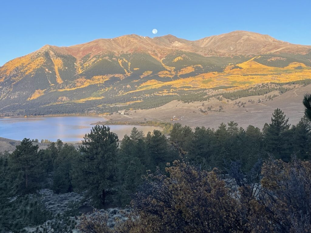
Both North Mount Elbert and South Mount Elbert trails obviously meet at the same summit. The summit photos in the gallery above that feature yellow fall foliage were taken in late September after hiking the North trail, and the others were taken in early September after hiking the South trail.
You can count on a few things remaining constant regardless of which trail you choose. One is that you’ll be hiking beneath forest cover for the first ~2.5 miles of the trip, then you’ll leave the trees behind and be exposed to the sun the rest of the way. Another is that while you might crush the first few miles at your regular pace, the last few miles before the summit will slow you way down. Especially on South Elbert, once I could finally see the summit I felt so close to it, but I just couldn’t get there. My legs were moving lazily because of the altitude. The last bit of both trails will also have a lot of loose rock. I typically hate loose scree because I worry about falling, but I felt pretty comfortable on the upper reaches of both trails (with one exception on the North trail which I’ll describe below).
Note as well that there is no water access on either trail, unless it’s snowed recently and you can use that as a water source (if there is snow or ice you should bring microspikes). You’ll need to pack in all your water. Keeping hydrated is extra important at elevation, so maybe bring one more liter than you think you need, and put an electrolyte tablet in one of your water bottles.
Regardless of which trail you choose, you will be gaining more than 4000ft of elevation from trailhead to summit. According to the Forest Service, South Elbert gains 4800ft and North Elbert gains 4400ft.

Colorado is famous for its summer afternoon thunderstorms, which is why most 14er hikers get an “alpine start” before the sun comes up (in which case you’ll need to hike with a headlamp). You want to try to summit and then get back down below treeline before a potential storm blows in. That said, I started hiking around 7:15am/7:30am-ish and summited around 11:30am both times, which might be considered late. My family lives near Twin Lakes and I was staying with them for an extended time prior to these hikes, watching the weather patterns. There were a few weeks where the skies over Elbert were totally clear every single day, so I felt confident with my start time. It was also September, which is generally less stormy than earlier summer months. Though, I know the storms are unpredictable, so I wouldn’t necessarily recommend that others make the same decision. I did pack a rain jacket just in case, but never used it. I can see on past trail reports that people who hiked North Elbert a week before me got a hailstorm, so I got lucky.
The summit will be cold, and possibly windy. Bring a warm jacket and beanie hat to change into, and maybe even gloves. Depending on how early you start hiking, you may want these in the morning too.
You may end up sharing either trail with Continental Divide Trail (CDT) thru-hikers. Mount Elbert is an optional side-hike they can do since the CDT forms the hypotenuse connecting South Elbert trailhead to North Elbert trailhead. They can leave the CDT at one trailhead, summit Elbert, and then rejoin the CDT at the opposite trailhead. Day hikers could also connect the South and North trails, if you wanted to ascend one way and descend the other instead of doing an out-and-back. You’d need to park different cars at each trailhead or have someone pick you up. It’s not a loop.
South Mount Elbert Trail Pros and Cons


Mileage: 6 miles one-way, 12 miles roundtrip
Trailhead: There are two possible South Elbert trailheads, both accessible from Twin Lakes, Colorado. The first and easiest to reach is near Lakeview Campground, however if you start hiking from here, it will add more mileage to your hike for a total of 15 miles roundtrip. If you continue driving 1.8 miles past the first South Elbert trailhead, you can park at the second one and shave some time off your hike. However, this is a rough road and some vehicles may struggle.
AllTrails / Forest Service
Pro-Tip: I parked at the Beaver Ponds instead (sometimes called the Lily Ponds). There are not many parking spots here, only a few cars can fit. Day hikers mainly park here to check out the ponds, but most people don’t realize South Mount Elbert is reachable from here too. The road is rough, but not quite as rough as the other one. It still ends up being 12 miles roundtrip when parking at the Beaver Ponds.
Crowds
When I summited Mount Elbert out-and-back via South Elbert trailhead on September 8th, a Friday, I didn’t see a single other hiker the entire time I was below treeline.
I believe I left the trees behind at about 12,000ft, and this is also where I began to struggle a bit more with my breathing because of the altitude. One solo hiker passed me around this time. At maybe 13,000ft, a solo trail runner passed me, and two guys who had already summited crossed with me on their descent. I started to see a few hikers far in the distance ahead of me, and when I was very close to the summit I met a couple more people who were coming down. Overall I didn’t share the trail with many other hikers at all. During my descent, I crossed five sets of hikers who were making their way up. One was a solo hiker about to summit. Two guys were carrying their bikes up. One couple seemed like CDT hikers. The other two parties were not CDT but seemed like they planned to camp at treeline that night and then summit the next day.
Views
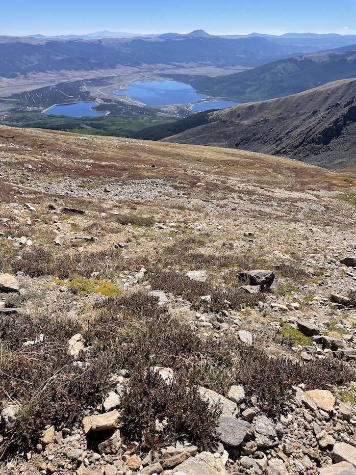
The South Mount Elbert Trail meanders through gorgeous open meadows as it slowly snakes its way towards the summit. The entire time you’re on the South Elbert trail, you have a view of Twin Lakes and Forebay Reservoir. I took an insane amount of pictures of these three bodies of water because the angle and perspective was constantly shifting; later on it was hard to choose which of my photos had the best vantage points!
Difficulty
The twists and turns in the trail make for a less strenuous and more pleasant ascent in comparison to the North trail which beelines straight up, although this same detail that I appreciated in the early stages of the South trail made things irritating towards the end.
When you get to the rocky stuff, the South Elbert trail is more forgiving than the North. You’ll never need to put your hands on the rocks to steady yourself or hoist yourself up. However, the trail becomes frustrating because when looking at a navigation app (I use GAIA), it seems like you’re so close to being finished, but you actually have more drifting around on switchbacks left to do. The switchbacks looked benign on the map but felt long to me in practice. I foolishly said to myself, “wow, maybe I’ll summit by 10:30am!” Then it was, “Ok, maybe 11am…” and then finally 11:30am. Especially when I curved around the last bend and could finally see other hikers up at the summit, the last stretch to reach them was demoralizing. Despite dragging one foot in front of the other I never seemed to get closer, and I had to take a lot of breathing breaks.
The rocks are a bit loose and shaley towards the end, but I didn’t find it scary.
North Mount Elbert Trail Pros and Cons


Mileage: 5 miles one-way, 10 miles roundtrip (Some sources say 9 miles roundtrip but most trail reports log 10 miles)
Trailhead: The North Elbert trailhead is accessible from Leadville, Colorado. You’ll take Half Moon Road to get there, and while it’s gravely and washboard in some places, it’s not as rough as the road to the upper South Elbert trailhead. Most cars will be able to handle it.
AllTrails / Forest Service
Difficulty
On South Mount Elbert Trail I didn’t struggle too much with my breathing until 12,000ft, but on North Mount Elbert Trail I was breathing hard pretty much the entire time, even below treeline (there are actually a few merciful flat places below treeline where I could catch my breath, but I assume I struggled more because it’s steeper overall. It was also colder in late September; breathing cold air in the morning made my lungs hurt). However, this swapped towards the end. The final stretch of the North trail before the summit did not seem harder than the rest; I kept pace and was suddenly there before I knew it. On the South trail I was really moving slow as molasses for the last few hundred feet.
On trail reports for the North Elbert trail, many hikers mention being frustrated by multiple false summits. I have to say I personally think this is overstated. Perhaps it’s because I had already summited Mount Elbert previously so I knew what it looked like, and therefore these mounds didn’t give me false hope – I knew none of them were the true summit (you would also be able to tell this by looking at an offline navigation app). But I also found that they did not add to the overall difficulty of the trail. Once I got over and atop one of them, the next one came quickly and it didn’t take very long to get on top of it either. It might only take 10-15 minutes to tackle each false summit. Of course there is huffing and puffing involved and I took breaks, but mentally these hills didn’t make me feel like the trail was being drawn out; I was always making progress. I was more frustrated by the meandering switchbacks in the last couple miles of South Elbert trail because it felt like I wasn’t getting anywhere.
There was one particular section on the North Elbert trail that was especially steep with loose dirt and rocks, right next to a bit of a drop-off. Ascending it was ok, though my feet did slightly slip. I thought, “this is going to be really horrible on the descent.” I get more nervous descending on steep trails than I do ascending. I hate that feeling when the traction on my shoe doesn’t grip the ground like it should and I do a brief Risky Business slide. Anticipating this section for the return made me consider descending via South Elbert trail and calling someone to come pick me up and bring me back to my car, but ultimately I decided to descend back via the North trail as planned. I took that section extremely slowly and it ended up being totally fine, I didn’t slip at all. This did increase the amount of time it took me to get down in comparison to my time for South Elbert, but I felt comfortable and I’m glad I didn’t cop out.
The upper part of North Elbert trail does have some places where it’s helpful to grip nearby rocks with your hands to steady yourself, but it’s not enough that I would classify it as a scramble.
Views
On North Mount Elbert Trail, your view of Twin Lakes is mostly cut off for the majority of the hike, although you will finally see them as you reach higher elevations. You can kind of see Turquoise Lake, though, next to Leadville. You’ll also have a view towards the Mount Massive Wilderness, whereas on the South trail you’re usually looking towards the Collegiate Peaks and Mosquito Range.
While I thought the South Mount Elbert Trail was prettier, some of the photos I got from North Mount Elbert Trail were cooler because they showed the more adventurous looking rocky ascents and descents. I feel more badass after having done the North trail.
Crowds
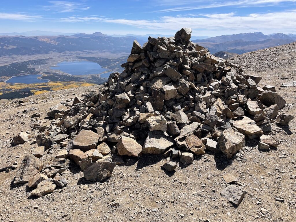
There were a lot more people on North Elbert trail than South Elbert trail. I hiked North Elbert on Thursday, September 28th. When I arrived at the trailhead, two different groups of two were also just arriving and starting their hike within minutes of me. After a mile or so, a solo hiker passed me and we continued to leapfrog with each other for a few miles. I passed one rather large group of maybe 8 people while I was still below treeline. Once above treeline, there were maybe 4 or 5 different solo hikers who passed me on their way to the summit. At the cairn just below the summit, I caught up to two hikers I had seen ahead of me for most of the hike. On the descent I passed quite a few parties still making their way up. Considering I hiked North Elbert late in the season and on a Thursday, I can only imagine how many people might be on it earlier in the summer on a weekend. When I hiked South Elbert a few weeks before, I do remember looking across at North Elbert (there is a place where hikers on the two trails can see each other; can you guess where on the map above?) and seeing tons of tiny ant-people making their way up via that trail. When I got to the summit and overheard the discussions of the other hikers, it seemed most had ascended via the North.
No matter which trail you choose, summiting Mount Elbert is a huge accomplishment to be proud of. For a moment, you are towering above everyone else in the entire state, and nearly everyone in the lower 48 (except for whoever might be standing atop Mount Whitney in California at the same time)! No matter how good of shape you’re in, breathing at 14,000ft+ is laborious. Your muscles are used to having more oxygen to fuel their work. If things are slow going, just keep putting one foot in front of the other and enjoy taking breaks to soak up the glorious Colorado scenery. Hike your own hike!
If you’ve hiked both trails out-and-back, do you agree with my assessment? Which was your favorite between South Mount Elbert Trail and North Mount Elbert Trail?
🏨 For the North trail, find budget hostels in Leadville here and standard hotel options here. If you plan on hiking South Elbert and want to stay in Twin Lakes, check out the Twin Lakes Inn or Roadhouse Lodge and Cabins.
✈️ Coming to Colorado from further afield? Use an Airalo eSIM for affordable international cell data and don’t forget to protect your investment with travel insurance.
Related:


Pin It:

My dream is to write travel and hiking content full-time. All of my guides and itineraries are free and my travels are self-funded. If you enjoy my site and would like to support, you can donate any amount to my Ko-fi page. Thank you!!
Did Mt Whitney and wheeler peak last year 🦅 going to do Mt Elbert, Mt massive and the 4 14ers going up 🦅then king peak, Gilbert peak🦅 trying to do all highest peak in USA🦅 thanks for the info🦅🤞🏽
I’ve only done the south route, but because I only have climbed the mountain in winter. The North Route road is closed in winter. That’s another advantage for the south route.
Thank you so much for making this post, so helpful for people like me, I am going to Leadville in July and planning this hike, i would prefer the south trail and park at Lily pond.
SUPER helpful information! Just climbed Mount Fuji recently, which was nowhere near as high. However, coming from a zero elevation Midwest state, the altitude was rough on Mt Fuji. I expect Colorado to be far harder. Thanks for the awesome post.
Wow cool, good job! I bet if you can do Fuji then you can do Elbert, at least breathing-wise at altitude. I just looked at some charts about the oxygen levels at 12k feet vs 14k feet and it seems to only be a moderate difference. Hope you enjoy if you make it out to Colorado!
Thank you for this helpful info. I’m hoping to do a double highpoint next summer with my son – Utah’s Kings Peak then Mt. Elbert a few days later. We’ll be coming from Austin, Texas and I think I need to plan 4-5 days of driving and 2-3 days of hiking per mountain. I’ll definitely choose South Trail.
What a cool trip idea, you guys will have a blast! I’ve never done Kings Peak. Are you guys ultimately trying to bag the highest peaks in every state?
Great explanation.
I’ve done North and planning south in August 2024.
Thanks Cliff! I think since you’ve done the North you should have no trouble on the South, the elevation challenge will be about the same but you can sit back and enjoy the views more. Have a great hike!
This is such a helpful comparison! Thanks for doing the research on the two main routes for us so we don’t have to. Also, very helpful to know this isn’t a loop trail so figuring out transportation would be important if you don’t do an out and back.