
Red Rock Canyon and Valley of Fire: Best Hikes for a Weekend in Nevada
Purchases made through some links on this page may provide The Detour Effect with commissions (at no extra cost to you). Thank you!
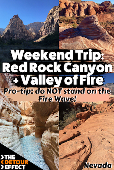
In October I spent a weekend in southern Nevada attempting to fit as many day hikes in at Red Rock Canyon National Conservation Area and Valley of Fire State Park as I possibly could. I’ve decided to finally write about how to plan a weekend hiking trip in these Nevada parks, because every time I log onto social media I see people posting selfies on top of the Fire Wave rock formation despite the fact that the Valley Of Fire brochure clearly states that they do NOT want visitors to do this. They are trying to protect the environment:

If nothing else, from this post I hope readers at least learn that one detail.
Red Rock Canyon and Valley of Fire FAQ
Can I stand on the Fire Wave at Valley of Fire State Park?
Say it with me: NO!
Can I fit both Red Rock Canyon and Valley of Fire into one weekend?
Yes! Red Rock Canyon and Valley of Fire are smaller parks and in one weekend you can cover a lot of ground on a self-guided hiking road trip, though you’ll probably mark down a couple additional activities for your “next time” list.
Are there guided tours to Red Rock Canyon or Valley of Fire if I don’t want to drive?
There are tons of guided day trips to Red Rock Canyon or to Valley of Fire departing from Las Vegas. Some of them mix in other stops like Seven Magic Mountains, Zion National Park, or Death Valley.
When is the best time to visit Red Rock Canyon and Valley of Fire?

I chose to visit towards the end of October in order to avoid the heat, but didn’t wait as late as November because Red Rock Canyon was begining their timed entry system from November 3rd through to May 31st. I got in there right before this went into place, and didn’t have the extra hassle of entry reservations. Note that nowadays, timed entry reservations are required from October 1st to May 31st.
The downside of this time of year was that desert tortoises go into a sort of hibernation called “brumation” from late fall to early spring, so I didn’t get to see any of the rescues at the Visitor Center. I didn’t have any wild tortoise sightings either, but this would be extremely rare anyway. The tortoise-crossing signs were the closest I got.
Even though it would allow you to avoid Red Rock Canyon’s timed entry system, I would not advise visiting either park in the summer. This is mainly because of the heat, but also because some Valley of Fire trails are completely closed in the summer, including the Fire Wave and White Domes.
So, it seems that winter wins in Nevada. November-February should be best time to visit Red Rock Canyon and Valley of Fire, and most years October, March, and April should be nice too. Although, just because it’s the desert doesn’t mean they can’t have freak snow storms. Be sure to check the latest alerts on both park websites before your trip in case of weather- or fire-related closures.
What do I need to know about Timed Entry?
Timed entry reservations are required for accessing Red Rock Canyon National Conservation Area’s 13-mile scenic drive between October 1-May 31 from 8am-5pm. This drive is how you reach all the most popular trailheads. You must make a timed entry reservation for each separate day that you plan on visiting the park. You can book your timed entry slot up to 30 days in advance. A few timed entry slots are held back for last minute bookings, which can be made 2 days in advance. If things aren’t sold out, “advanced” reservations can be made pretty much right up until your chosen entry time. This is all booked via recreation.gov.
Timed entry is not required from June 1-September 30, nor for very early arrivals prior to 8am. Timed entry is also not required if you are accessing an obscure trailhead that is not on the scenic drive.
If you have an America the Beautiful Annual Parks Pass, you only have to pay a $2 reservation fee for your timed entry. If you do not have a parks pass, you will pay $20 per vehicle + the $2 reservation fee when reserving your timed entry.
The scenic loop drive is one-way. If you accidentally drive past your trailhead, you have to exit the loop and start over from the beginning. Be careful about this – recreation.gov says that “Re-entry into the Scenic Drive after your one-hour entry reservation will require a new reservation.” Once you enter, you can stay all day until the park closes, but once you exit, if it’s been more than an hour since your timed entry slot began, you can’t come back in without a new reservation.
Valley of Fire State Park does not have a timed entry system. The day use entrance fee is $10 per Nevada vehicle or $15 per non-Nevada vehicle. Your America the Beautiful National Parks Pass won’t work because this is a State Park.
Where should I camp in Red Rock Canyon and Valley of Fire?
I made a campsite reservation in advance for the Red Rock Canyon Campground over at recreation.gov. At the time of my trip there were no advance reservations for Valley of Fire State Park; both the Atlatl Rock and Arch Rock campgrounds at Valley of Fire were first-come, first-served. However, as of September 2023 this has changed. You can now reserve through Nevada State Parks! Reservations are not a requirement and you still may be able to get a site first-come first-served when you show up day-of, but I wouldn’t chance it.
One of my favorite resources for finding free or paid campsites on nearby non-park land is The Dyrt.
What are the best day hikes in Red Rock Canyon and Valley of Fire?
According to my personal judgement, the day hikes on this list are in the easy to moderate range, with Turtlehead Peak being the only trail that could potentially be considered strenuous. Keeping the difficulty level relaxing is what allowed me to fit so many trails into one weekend. Depending on your fitness and hiking experience, you may feel differently about which trails are best for you. Be sure to review recent AllTrails trail reports to gather other opinions.
The drive from Flagstaff to Red Rock Canyon (near Las Vegas) is about four hours, so I woke up early on Day 1 hoping that if I arrived in the late morning or early afternoon, I’d still be able to fit a handful of hikes in before sundown. I made a few trails my priority and downloaded their routes to the GAIA navigation app on my phone before leaving for the drive, including Calico Tanks, Pine Creek Canyon, and Turtlehead Peak. I ended up also being able to fit in Lost Creek Canyon, but sadly didn’t get to check out the Ice Box Canyon Trail or White Rock Loop. For Valley of Fire, I prioritized Rainbow Vista/Fire Canyon Overlook, White Domes, and the Fire Wave, but missed out on the Pink Canyon/Pastel Canyon and the Prospect Trail. Read below for my trail reports from each park.
Day Hikes at Red Rock Canyon National Conservation Area


The drive in to Red Rock Canyon National Conservation area is already exciting before you ever get out of the car – check out the views above! These are the first pictures I took as I arrived. To get from viewpoint to viewpoint or trailhead to trailhead, you’ll take a 13-mile one-way scenic loop drive. Knowing that it’s one-way is important, because you’ll want to plan the order of your trails accordingly. If you miss a trailhead, you’ll have to drive the entire loop and come back around again to revisit what you skipped.
Calico Tanks Trail
Mileage: 2.4 miles out-and-back
Trailhead: Sandstone Quarry Parking Lot
AllTrails | Conservancy


The Calico Tanks Trail is one of the first possible stops on the driving loop, so it was my first hike of the day. It was busy with other hikers, as is to be expected from such an accessible trail, but I did have good stretches of time when I felt all alone (even though I knew other hikers were probably up ahead, around a rocky bend and hidden from view).
The first bit is flat, sandy, and a bit underwhelming, but before long you’re climbing up into a cradle of brilliantly-colored bright red rocks. You’ll also see pastel shades of pink and purple Easter-esque colors much like those that paint the White Domes Trail in Valley of Fire State Park. There is a ton of geological variation, as the rock itself appears to have been formed in a patchwork; sometimes it looks wind-swept, at other times porous.
You will likely need to utilize your hands to help hoist yourself up rocky stair steps occasionally, but this is still not a “technical” route by any means. There is one part where you walk along a narrow outcropping of a rock wall to cross from one section to the next (the righthand side of the eighth picture in the gallery above), which was a little nerve wracking, but it’s not a deep drop-off, and as an alternative you could probably just purposefully jump down below and walk across that way. At the end of the out-and-back trail you’ll come to a viewpoint overlooking rock formations and a valley that stretches all the way to Las Vegas itself. You are looking at the city from above!
Pine Creek Canyon Trail
Mileage: 2.4 miles out-and-back (or lollipop)
Trailhead: Pine Creek Trailhead
AllTrails | Conservancy


After Calico Tanks, I continued my drive along the Scenic Loop and stopped at the Pine Creek Canyon trailhead next. There is no shade for the first part of this hike, so be aware that you’ll be getting full sun exposure for awhile. When I went, it was still very hot even though it was nearing dawn, and also the end of October.
Once you enter the enclave of mountains, trees will begin to dot your path. You’ll come upon the foundation of an old abandoned homestead. As you continue from this point, the trail will become more and more overgrown. You’ll eventually find a creek bed below the shrubbery, and if interested in checking it out further you’ll need to duck under branches and push through brambles. Around this area you’ll hear conversations from rock climbers waft from the air above (see Climber’s Trail). You’re supposed to be able to do a lollipop route to meet back at the homestead and then retrace your steps to the trailhead from there, but to connect the loop you have to scrape through that creek bed and it is difficult to pinpoint. I ended up doing it as an out-and-back instead.
Lost Creek Trail
Mileage: 0.6 miles out-and-back
Trailhead: Lost Creek Trailhead
AllTrails | Conservancy


The sun was starting to hide behind the mountains, but was not yet setting behind the horizon, so I circled back around the driving loop and did the Lost Creek Trail, which I knew would be short and easy enough for a final bookend to Day 1. This one was extremely shaded the entire way by trees and rocks, and is more of a nature walk than a “hike”. You’ll walk over a wooden bridge that protects the running creek water and lush vegetation beneath. I saw a few bunnies on this trail! After this section the walk is shrouded in shadows as you navigate through tunnels of rock, which creeped me out actually. It reminded me of somewhere Scar and the hyenas from the Lion King would hang out.
After Lost Creek, I drove to my campsite and set up for the evening. The next morning, waking up to the sun streaming over Red Rock Canyon and casting hues of pink over the rock was truly a treat. I pulled over as I drove away from my campsite so I could try to capture it before the colors melted back to the grays and purples of the afternoon.
Near Lost Creek Trailhead is the parking lot for visiting the Petroglyph Wall, a must if you’re interested in Native American rock art.


On Day 1 I hadn’t managed to include Turtlehead Peak (by the time I arrived I figured it would be too hot for this one), and I knew that would be the toughest of the hikes I planned, so I saved it for a fresh morning start. The gamble I took by doing a hike in the morning instead of driving straight on to Valley of Fire was that I would probably miss out on a first-come first-serve campsite, but it was a risk I was willing to take to fit in one more trail. If I just have to park my car at some rest stop outside of Valley of Fire and sleep there the second evening, so be it.
Turtlehead Peak
Mileage: 4.6 miles out-and-back
Trailhead: Sandstone Quarry Parking Lot
AllTrails | Conservancy


I’ll tell you one thing that I do not like, and that is scree. I love a challenging incline that will get my heart and lungs working and I’m cool with plenty of other trail obstacles, but I am not a fan of scree. The last few miles of Turtlehead Peak are all scree, so if you’re like me, be aware!
As a result of being extra precious about my footing, I didn’t spend much time taking pictures on this one. The images above are mainly of Turtlehead Peak as I approach it via the trail. Once you reach the foot of the mountain itself, you start ascending very quickly on switchbacks full of loose sediment. The final picture above was taken about halfway up the Peak with my back turned to it, looking back out over Red Rock Canyon. It’s not nearly as expansive as the views from the top. You’ll have to find out for yourself!
Day Hikes at Valley of Fire State Park
Upon return from Turtlehead Peak I jumped back into the truck and finally set off for Valley of Fire State Park! The drive from Red Rock Canyon to Valley of Fire is about an hour. I made sure to listen to Johnny Cash’s “Ring of Fire” as I entered. Once again, simply driving into the gates of the park was enough to inspire. Can you tell which of the rock formations in the gallery below are called the “Beehives”?


On my way to the campsites to check if there were any spots left, I couldn’t help but pull off a few times at random arches to take more pictures of alien rock formations. When I finally got to the campgrounds, obviously they were totally full. I decided to drive on to my first hike and worry later about where to sleep.
Valley of Fire State Park has an official trail map and brochure. They provide a good understanding of where the trailheads are in relation to each other.
Rainbow Vista/Fire Canyon Overlook
Mileage: 1 mile out-and-back
Trailhead: Rainbow Vista Trailhead
AllTrails


I really loved the Rainbow Vista/Fire Canyon Overlook trail. In fact, to be honest, I think I loved every trail in the Valley of Fire more than I loved any of the trails in Red Rock Canyon. This one starts out on soft, bright orange desert sand that had me imagining I was walking in the Sahara (as long as I didn’t turn around and peek back towards the parking lot…but this soon disappears from sight). Then you enter into a canyon with rock formations lining either side. At the very end you arrive at the overlook, which is a fascinating, chaotic pit of rich red rock that looks like a portal to hell. This walk is not very challenging in any way, besides the initial resistance of the sand, so it’s a real bang-for-your-buck trail that will earn you a great payoff without much effort.
White Domes
Mileage: 1.1 mile loop
Trailhead: White Domes Trailhead
AllTrails (trail closed in summer)


The White Domes Trail has a variety of features all within one relatively short hike. You’ll start by descending steep rocky “stairs” leading down to a flat area at the bottom. On my way down, a few other hikers were going up the stairs in the opposite direction. They said they didn’t do the whole loop since it was so hot out and they were already tired, so they decided to turn back. I kept this idea in mind in case I might need to do the same, but I think they actually chose the worst possible way to avoid difficulty. If you continue on the loop, you get to go in the shaded slot canyon and then after you come out the other side, the walk back to close the loop is flat and easy, and not very long. Choosing to turn around and ascend back up some steep stairs is much worse!
At the bottom of the descent, I saw other hikers climbing up a rock tower that must be a popular spot to take pictures. One by one people were getting their picture on top of this big rock formation. It was busy and didn’t look worth it. I decided to skip that part and continue on the loop. Next up, you enter a gorgeous, pastel-colored slot canyon awash with soft pinks and oranges. I hadn’t researched the trail much beforehand, so I didn’t even know this was coming; it was a magical surprise! I was the only person in the slot canyon the entire time, so I felt extra lucky. I wonder if most people stop to take their picture on that other rock, and then turn back? They are seriously missing out if so!
After the slot canyon spits you out, you follow the trail past more brightly-colored yellow and pink walls and take a leisurely stroll back to the road. You’ll walk alongside the road for a brief moment to meet back up at the parking lot.
Fire Wave
Mileage: 1.3 miles out-and-back
Trailhead: Fire Wave Trailhead
AllTrails (trail closed in summer)


The Fire Wave Trail leads you on a short adventure across slickrock stuck in time, where the ground looks like the sand somehow froze in place in the middle of an active windstorm. It essentially did; much of the park is made up of ancient sand dunes, similar to the Petrified Dunes Trail in Snow Canyon State Park in Utah.
The final destination is a swirling peppermint candy rock formation called The Fire Wave, probably the Valley of Fire’s most popular attraction (the first two pictures in the gallery above). This is the formation the park prefers you not to walk on – take your pictures from afar! There are plenty of other great vantage points where you can perch to grab great photos of the Wave.
On my way out of the park, I made one last stop at Elephant Rock, which is way cooler looking from far away than it is when you’re up close on the trail that’s actually designated for viewing it.
Sunset at Lake Mead National Recreation Area
I decided to get a jump on my drive back to Flagstaff the second evening. Ultimately I was stoked that I didn’t end up getting to camp at Valley of Fire, because I rolled into Lake Mead with perfect timing to see a gorgeous sunset. It would seem the entire theme of this trip ended up being COLOR! Aztec Sandstone and Alpen Glow make for a psychedelic weekend road trip.


What’s your favorite trail in Red Rock Canyon National Conservation Area or Valley of Fire State Park? Have you spent enough time in either of these parks to discover more backcountry-style trails, or taken on any scrambly bouldering routes? What else would you shoehorn in to a short weekend in southern Nevada? Personally if I had more time, I would have driven another two hours into Southern Utah to visit Snow Canyon State Park. Or, if you’ve never been to see the Bonnie & Clyde death car or the Seven Magic Mountains art installation in Nevada, you could head further west!
🏨 Find budget hostels in Las Vegas or standard hotel options in Las Vegas.
🏜️ Take a guided day trip to Red Rock Canyon or Valley of Fire from Vegas.
✈️ Coming to Nevada from further afield? Use an Airalo eSIM for affordable international cell data and don’t forget to protect your investment with travel insurance.
Related:


Pin It:
My dream is to write travel and hiking content full-time. All of my guides and itineraries are free and my travels are self-funded. If you enjoy my site and would like to support, you can donate any amount to my Ko-fi page. Thank you!!
These are both BEAUTIFUL parks. My fiance and I took this trip in Feb 2020 – it was our last trip we’ve taken since the pandemic hit. Thanks for sharing the beauty of NV!
This is a place I haven’t yet been to, but would love to go to someday! Good idea to call out that people shouldn’t stand on the wave. I think many people don’t realize that, or just need to be reminded 🙂
I have never visited this area, but I have seen a few other blogs that write about it and I honestly didn’t know that you are not meant to stand on the wave! I have seen sooo many photos where people pose on there! It just shows we do always need your comments about your adventures (even if you don’t think we do!)
I love that there was so many short-ish hikes so you can visit a bunch of the sights in such a short time. I quite like travelling like this, as you can always come back or stay longer if you discover longer or more epic walks.
Did you camp near that view of Lake Mead!? What a stunning way to finish the trip!
I liked that you can fit a ton of shorter trails in as well! Gives you lots of perspective on different areas of each park. I’m not aware of a longer backpacking-style route that’s possible in either place (maybe it exists) but I feel like, while that would be fun, it wouldn’t provide enough of an overview of how different the landscape is as you drive across from one side to the other.
I didn’t camp at Lake Mead, just passed on by, but it gave me a total newsflash that I need to plan an entire trip just to hang out around Lake Mead! I didn’t realize how beautiful it is there, I thought it would be more industrial.