

Best Moderate Difficulty Day Hikes in Big Bend National Park
Purchases made through some links on this page may provide The Detour Effect with commissions (at no extra cost to you). Thank you!
I just spent the month of November hiking in Big Bend National Park while working remotely from my truck camper. I tried to do every trail suggested by the Park Service as moderate or difficult, plus a few trails rated as easy that have a cool feature or viewpoint. The below list compares and contrasts the best day hikes in Big Bend National Park vs. a few that I was underwhelmed by. I’ve given my opinions on whether or not I agree with the typical difficulty ratings.
There are some primitive routes that are not maintained or well signposted, which I did not attempt this time. You can purchase this Hiker’s Guide to Trails of Big Bend National Park to read about the primitive trail options. It’s available at most Visitors Centers and gift shops around the park.
If you’re visiting Big Bend country, be sure to read my Digital Nomad Guide to Working from Big Bend National Park. While a good portion of the post is about where to get wifi and cheap accommodation, I also included suggestions of additional things to do in Big Bend besides hiking, and general advice you need to know about planning a trip to Big Bend.
The Regions of Big Bend National Park
There are three main “hubs” of activity in Big Bend National Park: the Chisos Basin (center), Castolon (southwest), and Rio Grande Village (southeast). Each one has a developed campground and a Visitor Center.
Most of the hiking trailheads are located in one of these three regions, so if you have a few days in the park, it’s best to divide and conquer. Do the Chisos Basin area hikes over 1-2 days, the Castolon hikes one day, and the Rio Grande Village hikes another day.

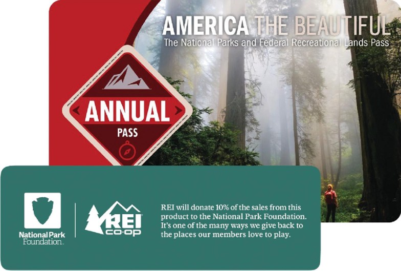
It costs $30 per vehicle to enter Big Bend National Park. This allows you 7 days of entry. Alternatively, you can show your America the Beautiful Annual Parks Pass. If you don’t order a pass in advance, they can be purchased from a ranger at the various entrance stations to the park such as Persimmon Gap or Maverick Junction.
Prefer a guided multi-day hiking tour at Big Bend National Park? Check out the 6 day trip offered by Timberline BH Adventures.
Best Day Hikes at Chisos Basin
Lost Mine Trail
4.8 miles out-and-back


The Lost Mine Trail is the first trail I did in Big Bend National Park, and after completing all the rest I still think it’s one of the top 3 best day hikes in Big Bend. It features some of the best views of the Chisos Mountains (though not THE best – that award goes to the South Rim Loop).
This trail is moderately difficult because it includes a good amount of uphill elevation gain, but I didn’t find it prohibitively challenging and there is nothing technical involved. It is scenic throughout, but culminates in an epic viewpoint at the end when you reach a flat, rocky mesa from which to look out over the Chisos Mountains.
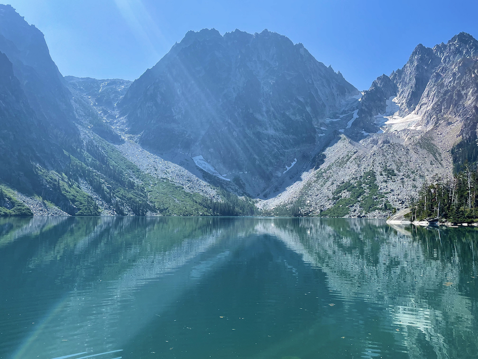
South Rim Loop
15 miles (12 miles without Emory Peak)


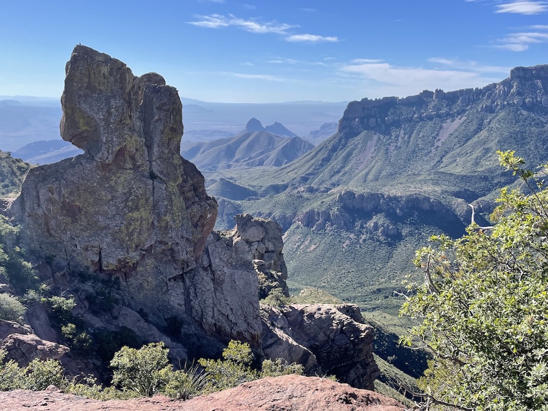
The South Rim Loop is absolutely world class and is without a doubt the best hike in Big Bend National Park. I have hiked throughout the States and Europe, and the famous view on this trail stands out to me as one of my favorites of all time.
There are many connecting trails so that you can choose your own adventure, but the classic route is to create a loop of Pinnacles Trail, Boot Canyon Trail, South Rim Trail, and Laguna Meadows Trail. It’s your choice whether to hike clockwise or counterclockwise. Personally I chose to begin on Pinnacles Trail and end on Laguna Meadows, because Pinnacles is steeper and rockier. I have good endurance when going uphill, but my knees can give me problems on a steep downhill. I was also worried about how hot it might get in the afternoon, so I wanted to save the gentler Laguna Meadows trail for the end of the day. I read that it was more shaded, although now having done the hike, the entire route really has a lot of shade.
Don’t get hung up on trying to figure out when each of these four trails ends and begins, especially when it comes to Boot Canyon. Just follow any signage for the “South Rim Trail” and you’ll be on the right course.
Other articles about the best day hikes in Big Bend pad their posts by naming each of these trails separately, which is misleading. This is all the same trail network. Some of them you can’t reach without beginning on another. For instance, it is impossible to do only Emory Peak or Boot Canyon trails in a vacuum; they are not their own “day hikes”. You must start from one of the other trailheads.
Emory Peak is the tallest peak in the Chisos Mountains. You can add this summit into your loop by taking a side trail out-and-back from Pinnacles, an additional 3 miles total. This is another reason I wanted to start on Pinnacles Trail; if you start at Laguna, by the time you reach the spur to Emory it will be towards the end of your day and you’ll already be tired. Note that the last few yards of the summit to Emory are a real scramble. If you have fear of sharp drop-offs, you may want to skip the last few minutes of this trail.
The incredible viewpoint that is the main treat on this hike is called the South Rim Viewpoint. It comes shortly after getting out of Boot Canyon and rounding your way towards Laguna Meadows. From here, you can see out over the entire park! To the west you’ll set eyes on Santa Elena Canyon and Mule Ears. To the east you can see Boquillas Canyon. I had hiked all three of these trails prior to doing the loop, so it was really fun to see everything from above.
Other trails that you can connect to the South Rim Loop include the East Rim Trail, Colima Trail, Juniper Canyon Trail, or Blue Creek Trail. You could create a multi-day overnight backpack by exploring these. Some people get permits to camp overnight just for the main loop if they don’t feel like hiking the full 15 miles (or 12 miles without Emory) in one day. I saw some of the backcountry campsites, and they have bear boxes to store your food in.
Window Trail
4.4 miles out-and-back


The Window Trail (not to be confused with the very short Window View Trail) is a relatively flat hike all the way through and not very strenuous. It must be rated as “moderate” in some places just because of the distance. It starts off in the desert with no shade, but winds into a canyon where rock walls envelop you. You end up at “The Window”, which is a break in the canyon walls that allows you to look out over the distant desert lands. It’s a cool destination, but my favorite part was just before the Window. You get to walk through what I’m inclined to call a “slot canyon”, although it isn’t really; it’s much too open to be considered a narrow slot canyon. It’s more of a dried creek bed, I suppose, which you can walk through since the water is mostly gone.
You can start from either the Chisos Basin Trailhead (5.6 miles roundtrip) or the Chisos Basin Campground (4.4 miles roundtrip).
Blue Creek Trail
3 miles out-and-back


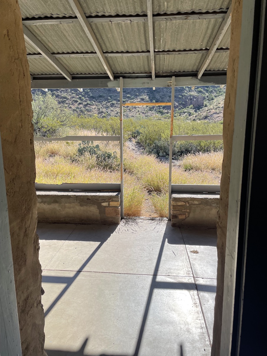


The Blue Creek Trail is actually 11 miles out-and-back if you hike the entire distance from Homer Wilson Ranch to the Laguna Meadows Trail junction, but for a short relaxing day hike, you can just follow the wash a short distance to check out the hoodoos and then return the way you came.
From the parking area, you hike down into a valley where the old Homer Wilson Ranch sits abandoned and begging to be explored. Walk inside the home and imagine what it might have been like to live off the land in the early 1900s. From here, you’ll follow the Blue Creek drainage and duck under tree limbs for about 1.5 miles. The exact route is not entirely clear as the drainage forks in multiple places, so keep an eye out for rock cairns to lead the way, but ultimately it doesn’t matter if you split off onto the wrong tributary – they all lead to the same place in the end. Red rock spires jut up into the sky at the end of the wash as the trail starts to curve up into the Chisos Mountains. I originally intended to continue past this spot, but I saw scat that I thought might be from a mountain lion and “noped” out of there. I have no idea if it really was, though.
Best Day Hikes at Castolon
Santa Elena Canyon
1.5 miles out-and-back


Santa Elena Canyon is another of my top favorites; I think this is one of the best day hikes in Big Bend National Park, despite it’s brevity.
You begin by walking the beach towards Terlingua Creek, and soon you’ll need to cross the Rio Grande. Supposedly this is no big deal when the water level is lower, but when I was there it was necessary to walk further up to find a dry spot to cross. Then, to get back to where the trail officially picks up on the other side, you sort of bushwhack back on course. The first part of this requires holding onto rocks to steady yourself, but soon you’re walking alongside the water and ducking under foliage on flat ground.
If this sounds intimidating, rest assured that plenty of other people have worn a trail into the terrain. Each year this “trail” changes a bit depending on where people need to cross in response to water levels, so there’s not really a right or wrong route. That said, it was easier for me to follow on the way in because I could see other hikers ahead of me. On the way back no-one was leading the way and I did get confused trying to find the place where I had gotten up the rocks before. I should have set my GAIA app to track my realtime route so I could follow it back. Downloading an old offline map of this trail from the internet isn’t helpful when the water levels force hikers to find alternate routes.
As you enter the canyon itself, you’re initially following a paved route with information signs about the geology of Santa Elena Canyon. Then you’ll follow the dirt trail alongside the Rio Grande and deeper into the canyon, where temperatures quickly drop. You’ll walk until you literally hit a wall and cannot continue further, then trace your steps back.
I loved this trail because it felt like walking back in time. The terrain, flora, and fauna really drive it home that hikers are traversing the bottom of an ancient ocean.
Alternatively, visitors can kayak into Santa Elena Canyon. In an episode of Parts Unknown where Anthony Bourdain visits Marfa and Marathon, he does a canoe trip here. You can swim in the Rio Grande too – don’t forget your swimsuit!
Mule Ears Spring
3.8 miles out-and-back


Mule Ears is a rock formation along Ross Maxwell Scenic Drive that looks like, you guessed it – a pair of mule’s ears. The hike to get to the Mule Ears Spring has absolutely no shade whatsoever; this is a true desert hike and not a great choice for a summer day. The day I did this in early November, I was trying to fit one more hike in after completing a few others and made the bad decision of starting the Mule Ears trail around 1pm. I got overheated and thought the safe choice would be to turn back early rather than continue all the way to the spring. Try this one earlier in the morning or later in the season.
When sources rate this trail as “moderate”, it must be in reference to the heat and possibly the distance. There is negligible elevation change and nothing technical.
Trail reports online attest that the spring itself is unremarkable, but the desert plants and colors along the trail are a highlight. For the distance that I hiked, I thought the rock shards that made up the trail were quite forbidding and cool looking, like a moonscape.
Chimneys Trail
4.6 miles out-and-back


The Chimneys Trail is exactly like Mule Ears when it comes to being a long, flat desert hike completely exposed to the sun, but the endpoint is much more rewarding. I did this trail later in the month and didn’t suffer from heat this time.
At the end of the trail are the “Chimneys”, tall rock formations in the middle of nowhere. Apparently they were significant for indigenous populations, and you can hike right up to Native American petroglyphs carved into the rock! Nobody else was around when I got to study the petroglyphs and it truly felt like a sacred place.
I took a lot of pictures of cactus, ocotillo, and even a tarantula on this trail.
Again, there is no elevation change and nothing technical. I would rate the Chimneys Trail as easy.
Best Day Hikes at Rio Grande Village
Hot Springs Trail
1 mile or 3 miles out-and-back


The Hot Springs Historic District features abandoned buildings built in the 1900s-1920s to enable tourists to enjoy the “healing waters” of the nearby hot springs on the Rio Grande. You can still soak in the springs today, though the buildings are a relic of the past.
There is the upper trail and the lower trail. The lower trail is only 0.5 miles to the hot springs and the upper trail is 1.5 miles. Both are very easy. When I was there, a sign said the lower trail was closed for dangerous conditions, so I took the upper trail. I met hikers at the hot springs who said they took the lower trail and didn’t encounter any issues, so I took that for the return to the trailhead and I also didn’t have any problems. The lower trail is cooler than the upper trail because you get to walk riverside next to strange rock walls, but on the upper trail you get a nice view over the Rio Grande.
There are supposed to be Native American pictographs on the rock walls on the lower trail, but I couldn’t find them.
Boquillas Canyon
1.3 miles out-and-back


Boquillas means “little mouths” and likely refers to the cave-like depressions you’ll notice in the cliff walls as you hike along the Boquillas Canyon Trail. This trail leads you down to the part of the Rio Grande where the river leaves the desert and travels into the eastern cliffs, much like Santa Elena Canyon to the west, but you won’t be hiking inside the canyon like you do at Santa Elena. Instead you’re hiking along a beach, and at some points under tree cover. It’s very easy, but still, this is a trail that’s not enjoyable on a hot afternoon unless you’re going for a swim!
Nearby is the Boquillas Del Carmen port of entry to cross the border into Mexico. Along the Boquillas Canyon trail, people sell their wares to passing hikers. Usually it’s tchotchkes and souvenirs, but I also saw a sign for tamales!
Best Miscellaneous Day Hikes
Grapevine Hills Trail to Balanced Rock
2 miles out-and-back


The Grapevine Hills Trail is very close to Panther Junction and not quite in the Chisos Basin, so I’m listing it in its own category. To get to the trailhead you’ll drive a long, somewhat rough road (nothing too crazy) called Grapevine Hills Road. The main feature you’re looking forward to on this hike is a formation called Balanced Rock.
The hike begins through flat desert terrain, but soon you’ll climb up some rocky “hills”. I suppose you could describe parts of this as a “scramble”, but it’s not treacherous and there are no drop-offs. In addition to the Balanced Rock itself, I also enjoyed this hike because of the expansive views out over the desert. Qualitatively it reminded me of the Maze hike in Joshua Tree.
I would personally rate this hike as easy, but I did notice a few older folks getting tired during the hilly part towards the end.
Big Bend Ranch State Park
If you decide to leave the National Park and venture into the nearby State Park, one trail is clearly the best day hike in Big Bend Ranch State Park: Closed Canyon Trail (1.8 miles out-and-back).


The walls of Closed Canyon tower high above you and the sun highlights the upper reaches. Nobody else was there when I hiked it, so it felt truly desolate and lonely in the best possible way. I felt like an explorer discovering it for the first time.
The very end of the trail becomes waterlogged. I shimmied past a giant puddle by clinging to the rock wall, then on the other side of this I needed to slide down a slope. Immediately after the slope, a sign informed me I was at the end of the trail, so the effort of sliding and clinging to the walls was really unnecessary. Other than this, the trail is very flat and easy.
I also did the Hoodoos Trail, which I found pretty boring, and part of the Fresno Divide Trail, which was ok but didn’t knock my socks off. Maybe if I had completed the entire loop of the Fresno Divide Trail to the Dome Trail I would have been more impressed. There are ruins of an old mining settlement on the Dome Trail. This was another day when I saw unidentifiable scat and felt a bit paranoid about continuing, plus I only planned to spend one day in the State Park and that loop was going to take up too much time.
In my guide to Big Bend National Park, there is more information about things to do around Big Bend Ranch State Park that don’t involve hiking, such as seeking out petroglyphs and touring Fort Leaton. A $5 Big Bend Ranch State Park day pass can be purchased at Barton Warnock Visitor Center (east entrance) or at Fort Leaton State Historic Site (west entrance).


Tips for Hiking at Big Bend National Park
Temperatures and Weather
Spring and Fall are the best times to visit Big Bend National Park for hiking. Summer temperatures can be brutal. I was there for the month of November, and some of the early November afternoons were still very hot. It was important that I get off the hiking trails before 1:30-2pm, especially for the lower elevation hikes like Mule Ears. That said, mornings and nights were cold, which is typical of the desert. Towards the middle and end of the month, the afternoon weather was perfect and I no longer felt like I needed to cram all my hikes into the early morning hours. As December neared, there were a few days of sleet and freezing wind. Since I was staying in my truck camper, I was glad to leave before the nights got even colder.
The hikes around the Chisos Basin mountainous region are higher in elevation, have a good amount of tree cover, and will not be as hot in the afternoons. On cooler temperature days, you can spend more time on the lower elevation desert trails with no shade, such as Chimneys, Mule Ears, and Boquillas Canyon. Soaking in the Hot Springs is probably something you want to reserve for cooler days too. Santa Elena Canyon is a bit of an anomaly; the first quarter mile is exposed to the sun and hot, but once you get into the canyon, the temperatures are quite cool, even cold.
Be prepared for changing temperatures by bringing plenty of water, snacks, and the ten essentials. Bring extra water of your own to keep in the car and refill periodically, but if you do start to run out of water, you can use the potable water pumps at Chisos Basin Campground/Visitor Center or Panther Junction Visitor Center.
Visiting in the springtime will likely be more crowded than autumn, but waterfalls and springs should be more powerful that time of year.
Wildlife
Be cognizant of the wildlife you are sharing the park with. The Big Bend is mountain lion, black bear, and rattlesnake country. I never saw a predator, but I did see tarantulas, white tailed deer, and plenty of scat. These hikers on the South Rim Loop trail witnessed a mountain lion attacking a deer! Pack your food Leave No Trace style or leave scented items in the provided bear boxes at various trailheads and campsites. Consider avoiding hiking at dawn or dusk if you’re worried about mountain lions, though of course they are elusive and your likelihood of seeing one is extremely low. Bring a can of bear spray.
Check out this incredible documentary about the wildlife of Texas called Deep in the Heart, narrated by Matthew McConaughey.


Emergencies
Because the park is so vast and there is not always cell service, it’s a good idea to bring an emergency communication device such as the Garmin InReach Mini. I also use the GAIA navigation app on my phone to save offline trail maps for hiking, and I’ll even reference this for driving sometimes.
It might be smart to have a spare tire on you as well, especially if you plan on driving some of the rough backroads. When I was in Big Bend Ranch State Park, a ranger specifically advised me to have one or two spares before trying to search for a petroglyph site off Casa Piedra Road and Main Park Road.
Before your trip, check the Alerts & Conditions section on the park website to find out if any roads or trails are closed or will have treacherous conditions during your stay.
When I arrived at Big Bend National Park, my goal was to hike not only the most iconic trails, but also to explore some of the lesser known day hikes that are not always included on these types of lists. I found some trails on GAIA such as Elephant Tusk to Tortuga Mountain, for instance, which is not recommended on most Park Service materials. However, when I asked a ranger about these trails, he said they are poorly defined and basically full-on bushwhacking. I found this odd because GAIA marks Tortuga Mountain via Elephant Tusk as “easy”, but I figured it’s best to believe the Park Rangers. I wasn’t in a bushwhacking mood this time around, but I’d love to come back sometime and branch out. What are your favorite lesser known day hikes in Big Bend National Park?
🏕️ Search for nearby campites, free or paid, at The Dyrt.
🏨 Find hotels near Marathon, TX, in Marfa, or in Alpine.
✈️ Coming to Texas from further afield? Use an Airalo eSIM for affordable international cell data and don’t forget to protect your investment with travel insurance.
Related:


Pin It:

My dream is to write travel and hiking content full-time. All of my guides and itineraries are free and my travels are self-funded. If you enjoy my site and would like to support, you can donate any amount to my Ko-fi page. Thank you!!
Love your descriptions and pictures. Big Bend was the first place I ever went backpacking (about 45 years ago) and the first place I went hiking with my kids (about 25 years ago). This post brings back a lot of memories.
I’ve only hiked there in the spring one time. The gnats convinced me to never do that again. I prefer November, but I have camped on the South Rim in August.
Thanks Art! What a great place to get hooked on backpacking. Was August unbearable with the heat? I suppose up at elevation on the rim it’s probably better than down below. I didn’t have any gnat problems in November either, except on the Hoodoos trail at Big Bend Ranch State Park for some reason. They were swarming.