
Was Cabeza de Vaca the First European to See Big Bend National Park?
Purchases made through some links on this page may provide The Detour Effect with commissions (at no extra cost to you). Thank you!
In April of 1528, the Narváez expedition from Spain landed in Florida with the hopeful intention of starting a colony and exploring the New World. After a series of harrowing mishaps and shipwrecks fit for a Hollywood movie, by 1529 only four survivors remained of the initial 600, including Alvar Nuñez Cabeza de Vaca. Over the ensuing years, de Vaca became a merchant among the Native Americans before being captured by Mariames on the Gulf Coast. He believed himself to be the only remaining survivor of the original expedition, but miraculously reunited with three others in enslavement. The four castaways finally escaped their captors and began a journey across the southern United States and northern Mexico, their luck shifting as natives began to hail them as healers. They finally reached other Spaniards in Mexico City in July 1536 and were welcomed as heroes.

Using de Vaca’s own written accounts of his journey as well as Gonzalo Fernando de Oviedo y Valdez’s personal interviews with de Vaca, scholars have attempted to reconstruct the route of these four survivors. His original descriptions of the landscape, flora, and fauna are vague. Many different route theories have sprung up, none of which can be fully confirmed. Some of the researchers who have developed Cabeza de Vaca route theories include Alex D. Krieger, Cleve Hallenbeck, Alessio Robles, Carlos Castañeda, Robert T. Hill, Harbert Davenport, Joseph K. Wells, and T.N. and T.J. Campbell.
As a hiker and national parks enthusiast, I’m interested in where exactly Cabeza de Vaca crossed between Mexico and Texas and whether he entered Big Bend National Park or Big Bend Ranch State Park.
After finding an article called On the Trail of Cabeza de Vaca, Texas’ First Travel Writer published by Texas Highways, I reached out to professor Donald Olson of Texas State University, author of Pinon Pines and the Route of Cabeza de Vaca, who kindly provided me with maps and some additional reading materials from Krieger. Krieger’s book We Came Naked and Barefoot: The Journey of Cabeza de Vaca across North America is very detailed and addresses points made by all the prior researchers, so it is my main source. In Donald E. Chipman’s In Search of Cabeza de Vaca’s Route across Texas: An Historiographical Survey where he reviews existing theories in order to choose the most likely, he agrees that “Krieger’s route interpretation meets the criteria of thoroughness and objectivity.” He also believes T.N. and T.J. Campbell’s work is a good “refinement” of Krieger’s, but mainly in regards to later stages as they accept Krieger’s perspective on the Big Bend leg of the route.
From Monclova to Presidio
On this map from Alex D. Krieger’s 1961 article The Travels of Alvar Nuñez Cabeza de Vaca in Texas and Mexico, 1534-1536, I’m looking at the points marked 6 and 7, and the space between them:

Cabeza de Vaca wrote that he crossed 30 leagues of plains after what we can assume is Monclova (6), followed by 50 leagues of dry rocky terrain, and finally crossing a large river before reaching the “people of the cows”, which all the scholars agree refers to the La Junta near Presidio (7).
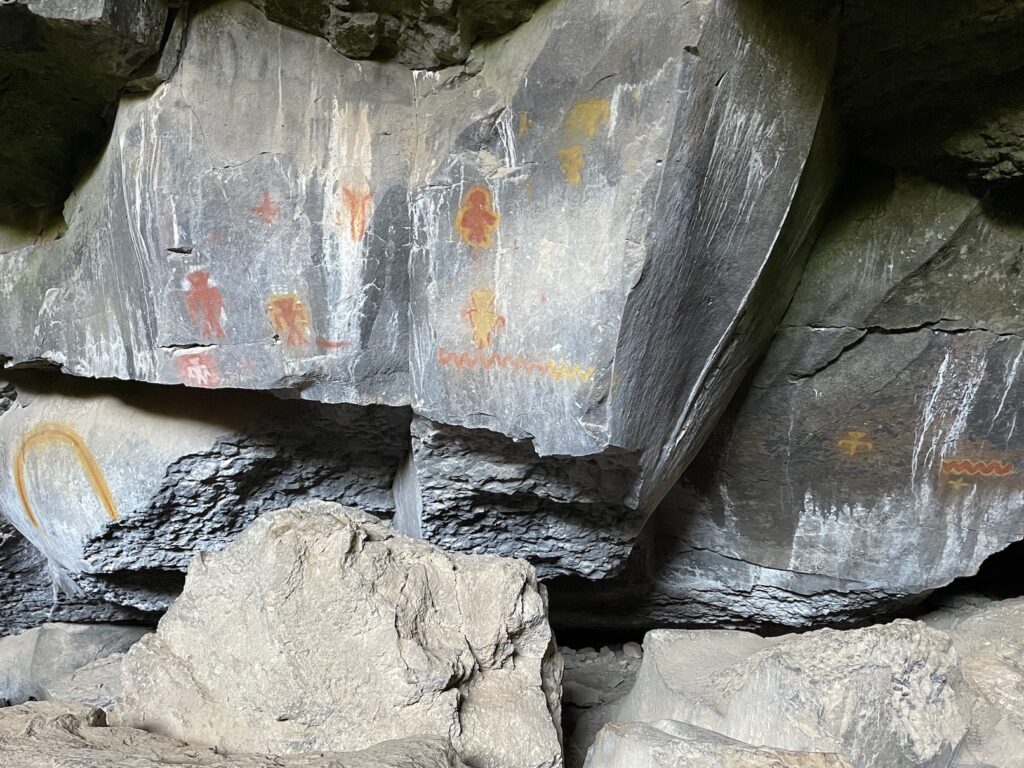
Today you can visit Fort Leaton State Historic Site near Presidio to learn about the La Junta (groups of people who lived in an area known as La Junta de los Rios in far West Texas). If interested in tracing native history in the area further back, I recommend visiting the rock art sites in Big Bend Ranch State Park.

Krieger says the requirements are met by identifying “the 30 leagues of plains as those of the Babía Valley, the Valley de los Guajes, etc; the 50 leagues of dry, barren, and rocky country as the arc between the Sierra del Carmen on the east and the Lower Río Conchos on the west; and finally, the second large river as either the Río Conchos or the Río Grande near their confluence”.
But, there is quite a lot of space between the Sierra del Carmen to the east and the Rio Conchos to the west underneath Big Bend country. Krieger’s map suggests the group walked parallel to the Rio Grande in the Parque Nacional Cañón de Santa Elena in Mexico for this whole period (Highway 200 essentially does this today), finally crossing a river into Texas near Presidio, missing both Big Bend parks by a small margin.
He denounces Robles’ theory that the group went “through the Big Bend area to Presidio”, saying its “unlikely because of the very deep, vertical canyon walls”. There are parts of the Rio Grande in Big Bend National Park and Big Bend Ranch State Park that are not surrounded by canyon walls, such as near the Hot Springs trail, Hoodoos trail, or at Lajitas. The ease of crossing between countries is highlighted by the presence of modern day border patrol at Boquillas and US 385 (I’m not suggesting Cabeza crossed at Boquillas or Hot Springs specifically). The simple act of crossing the river itself is not the issue.


If the idea is that traversing Big Bend country near the border is too difficult in general, I wondered if walking through Parque Nacional Cañón de Santa Elena the entire way is not similar terrain? After all, if we ignore man-made country borders between America and Mexico, Big Bend National Park and Parque Nacional Cañón de Santa Elena could be one unit.
Krieger expands on his reason for believing they walked parallel to the Rio Grande in Mexico for some time:
“For one on foot, this land would be extremely difficult not so much from physical difficulty as from lack of plant or animal food. It occurred to me that, being so close to the Rio Grande and parallel to it, the four travelers would have wished to descend to the river and follow it. However, Dr. McAnulty negated this, saying that the canyon of the Rio Grande itself would have been even more difficult to travel and that there would have been no point in descending to it even though the Indians knew it was nearby. Although Cabeza de Vaca complains about the barrenness of the country and lack of food, he says nothing about lack of water. The present truck road that goes from La Babía Ranch westward into Chihuahua stays well away from the Rio Grande canyon but passes a few small springs. Undoubtedly the Indian guides knew well enough how to find water in this land without following the tortuous canyon.” For reference, “Dr. McAnulty had just completed more than a year of intensive mineral survey in northern Coahuila, examining virtually every square mile of that terrain.”
I suppose this makes sense; from my time in Big Bend National Park I’m not aware of many springs or water sources on the Texas side of the river until you get closer to the Chisos Mountains, except Mule Ears Spring and Terlingua Creek. Maps also show something called Aqua Adentro Spring and Rancho Viejo Spring in the State Park. I was unfamiliar with these, so I asked Tim Gibbs, Park Archeologist at Big Bend Ranch State Park, about water sources. He explained, “Generally speaking, springs and other water sources are regionally rare and discontinuous. That said, BBRSP has the highest concentration of springs in the region thanks to its unique volcanic geology. Most springs in the park are located in the canyons where resistant and impermeable basalts are exposed at the surface. Not surprisingly, these support rich and often isolated riparian areas that, based on the resultant cultural materials, also facilitated prehistoric human activity. Most of these springs are concentrated in the Fresno Canyon and Bofecillos physiographic areas, though they are also abundant along Alamito Creek.”
Therefore it doesn’t seem impossible to sustain life by walking parallel to the river on the Texas side, but regarding a Mexico route, Gibbs agrees “The terrain through northern Coahuila and Chihuahua is mountainous basin and range province, but has generally more abundant water resources than the corresponding country north of the Rio…That reach between Boquillas and Lajitas is problematic for a number of reasons, the most notable being the dearth of water, dissected terrain, and numerous deep canyons along the Rio Grande.”
One thing that sticks out to me about the Wittliff Collections translation of de Vaca’s original manuscript is the word “mountains”:
“These people guided us through more than fifty leagues of uninhabited and rugged mountains. Since it was such dry country, there was no game in it, and for this reason we suffered a great deal of hunger. After this we crossed a very large river, with water up to our chests. From this point on many of the people we had with us began to suffer from the great hunger and hardship they had endured in those mountains, which were extremely barren and harsh. These same people took us to some plains near the mountains, where other people were coming from a great distance to receive us.”
Krieger spends ample time describing another conversation with McAnulty where the goal is to establish that the party could have easily walked on a flat plain for these 50 leagues. “I asked him how one could travel from the upper Sabinas valley to the Río Conchos–Río Grande confluence without crossing high mountains. To my astonishment, he answered without hesitation that the country west of the headwaters of the Río Sabinas is open and there is no barrier to travel…The large, open plain just south of the Big Bend provides a convenient place for Cabeza de Vaca and his companions to have gone westward.” Why is Krieger trying to establish a route for de Vaca to avoid mountains, when de Vaca’s own retelling says they did walk through rugged mountains? Perhaps I am looking too far into the word “through”. I suppose the 30 mile wide plain in between the Sierra del Carmen mountains and Sierra de La Encantada mountains, or the valley area of Highway 200 between Manuel Benavides and Ojinaga, could both be described as walking “through” or between two mountain ranges, but de Vaca does not mention a “plain” until later, after the river crossing.
Davenport and Wells’ The First Europeans in Texas, 1528-1536, II doesn’t add much detail. “The barren mountains are found on both sides of the middle Rio Grande. A journey of fifty leagues through this barren and inhospitable region would take the travelers across the Rio Grande in the “Big Bend” country, and well into the limestone plateau beyond. Presidio, near the Rio Grande-Conchas junction, lies thirty leagues or more to the west, across a similarly barren and rather mountainous region.”


When I asked the National Park Service for clarification on what sort of plains and water sources de Vaca might have encountered during this portion of the walk, they reminded me that the landscape may have looked very different then. “There were grassy plains before ranching occurred, for example.” As far as water access, “there were probably more natural water sources during de Vaca’s time. Many natural springs have dried up as the water table drops.” Gibbs from the State Park agrees that “The Big Bend would have been unrecognizable to modern eyes” because “the climate was much wetter and cooler in the 1530s when Cabeza de Vaca made his way through La Junta. The Little Ice Age, or Holocene Climatic Minimum, was a period of cold conditions between roughly AD 1350 and 1880 that had a dramatic effect on the cultures of the Southwest and has been attributed to the ‘collapse’ of Formative cultures across the region.”
Crossing the River
Krieger says “several days’ travel intervened between crossing the ‘very large’ River 6 and reaching the people of the cows…we must conclude that it was either the Conchos above the junction or the Rio Grande below the junction”. He goes on to explain that many native settlements existed along both rivers near the confluence, according to the Espejo expedition that again explored this region 47 years later. Some Native Americans that Espejo met during this expedition even remembered meeting de Vaca’s party.
Determining whether Cabeza de Vaca crossed from Mexico into Texas on the Rio Grande prior to the confluence or on the Rio Conchos after the confluence would provide a major clue as to whether they might have entered the bounds of Big Bend Ranch State Park or Big Bend National Park. The parks are both located along the Rio Grande east of the confluence. Rio Conchos does not touch either park.
It could take “several days” of walking from various points within the State Park to reach Presidio/La Junta. It would also take “several days” to walk from points within the National Park to Presidio (how many days is “several?” This is confusing to determine from the original manuscript; see below). If they were to cross the river outside of the western edge of Big Bend Ranch State Park via either the Rio Conchos or Rio Grande near the confluence, missing both parks completely, it seems like they would hit one of the many settlements along the rivers rather quickly.
That said, the La Junta area isn’t necessarily synonymous with today’s town of Presidio; it extended approximately 25 miles out in every direction. Depending on where exactly the native settlement was, we can’t rule out that they crossed the river closer to the confluence and not within park bounds. Cabeza de Vaca also mentions that many of the people native to this area were away at the time hunting bison further north, so they might not have run into them as quickly as they would other times of the year.
“The principle Indian pueblos of the La Junta were all located within a radius of six leagues, or some 16 miles, of the actual junction of the stream.”
J. Charles Kelley, The Historic Indian Pueblos of La Junta de los Rios
We know that after crossing the river, they walk some unknown distance to a “plain”. They send two Native American women ahead to find the La Junta people. Cabeza de Vaca’s group walks an unknown distance, stopping at a place they had agreed to meet the women upon their return. They rest here for around 8-10 days. When the women return (saying they had found very few people), the group travels for 3 days looking for these “very few” people. On the morning of the 4th day, most of the travelers stay back while Estevanico and Alonso del Castillo follow the two women “to a river that ran through some mountains, to a village where her father lived” 7.5 leagues away. After making contact, they return to grab the other Spaniards and bring them to the village, where in fact there are many people. It may not be the same people the women were originally looking for. “We stayed there for a day, and the following day took them with us to another permanent settlement where they ate the same things as these people.”

So, between crossing the river and reaching La Junta, there is an unknown distance to the plain, an unknown distance to the meeting place, then 3 days plus 7.5 leagues (22.5 miles) of travel to reach the first village. The next day they travel to the second village.
If they were walking on average 10-15 miles a day, plus the extra long 4th day, then we might say the distance between the meeting place and La Junta could be between 50-70 miles. It may be more if they hustled and walked 20+ miles a day. Unfortunately we don’t know where the meeting place was, or the plain they first encountered after the river. Krieger assumes the plain and meeting place must not be very far away from the river.
What was their water source while resting for 8-10 days at the meeting place while waiting for the women to return? Later, de Vaca makes a point of saying the party was finally led “to a river that ran through some mountains, to a village where her father lived”, which makes me think this river was a new phenomenon and not something they’d already been following up to that point (to their knowledge).
Cabeza de Vaca also says that 8 Native American men died during the time they were waiting for the women to return. Perhaps in the future, 8 burial sites will be discovered by archaeologists.
Considering Other Sources

The Davenport and Wells “probable route” shown on this map has them crossing the river much further east of Boquillas (closer to Dryden) and making their way through the parks towards Presidio, perhaps missing the bounds of the National Park but still crossing the Old Comanche Trail and then cutting through the State Park. I want to believe this for the sake of my interest in the parks, but from this crossing location it would take longer than “several days” to walk to Presidio. Krieger also debunks this route in his book because he says they didn’t quite follow the “30 leagues” and “50 leagues” descriptions of mountain ranges and valleys after Monclova.
If we (and Chipman, McAnulty, and the Campbells) accept Krieger’s theory about the route from Monclova up through Mexico, we must reject all suggestions that the party crossed through central Texas and the Austin area (such as Hill’s theory). These routes are not taken seriously by other experts because they neglect important clues from de Vaca’s descriptions of local plant and animal life, as well as ethnographic information relating to human populations encountered along the way.
I do think because of de Vaca’s complaints about lack of food, the party probably did not walk through the Chisos Basin, where there is abundant wildlife and plant life. I’ve seen it myself while hiking in Big Bend. If they crossed through Big Bend country I would assume it to be in the State Park or the Castolon area of the National Park. Krieger favors the idea that they crossed west of the confluence on the Conchos River and never stepped foot in either park at all, though I still question whether this could accurately be described as “several days” from any La Junta people, especially considering the certainty with which he holds that “In summary, considering all of the above, there seems very little doubt that the people of the cows lived in the confluence area of the Río Grande and the Río Conchos.”

In J. Charles Kelley’s article about the historic pueblos of the La Junta, there are multiple stories of explorers crossing the Rio Grande again and again over the centuries while coming into contact with these people. Studying these reports, and Texas Beyond History‘s archaeological summaries, more in depth may provide ideas as to where exactly the settlement was located that de Vaca came into contact with. For instance, we can probably rule out contact with the settlement at Polvo/Tapacolmes near Redford because they’ve dated it as active in the 1300-1400s.
Other potentially helpful sources in this vein include Mecham’s The Second Spanish Expedition to New Mexico, Antonio de Espejo and His Journey to New Mexico, and Kenmotsu’s Seeking Friends, Avoiding Enemies: the Jumano Response to Spanish Colonization. The more I read into these, the more confused I get about the difference between the bands of people living at La Junta de los Rios, including the Abriaches, Otomacos/Patarabueyes, and Jumanos. Kenmotsu says the Jumano band were the main bison hunters and they really lived about four days northeast of La Junta on the Pecos River. They only visited the La Junta area nomadically. They were cordial with the settled Abriaches and Otomacos near the confluence, but not particularly great friends. Mecham says “Those bordering on the Pazaguantes on the Conchos River and extending some distance up the Rio Grande, were called Patarabueyes or Otomoacos. Those living at the Rio Grande-Conchos junction and south of it were called Abriadres. The Indians who roamed the plains northeast of the Rio Grande in quest of the buffalo were the Jumanos proper.” Krieger says “The Indians 5 leagues above the junction and at the junction were called ‘Abriaches’ and spoke a language different from the Otomacos, ‘though related to them.’ Both the Abriaches and the Otomacos were called ‘Patarabueyes’ by the Spaniards.” Other sources discuss the Jumano as basically being synonymous with the La Junta people at the confluence.
When the women could not find people because they had gone north to hunt bison, I would assume they were looking for the Jumano people who roamed towards the Pecos River. Perhaps when these people were in the La Junta area seasonally, they camped at a site on the Rio Grande called Arroyo de la Presa, described by archaeologists as not being a permanent settlement. “In that area of the site, hunting and gathering groups repeatedly camped over a time span of about 1000 years, beginning around A.D. 700.”
I’ve wondered if perhaps the Jumano settlement on the Pecos is the village along the river through the mountains, because heading north after crossing the first big river (instead of hanging around the confluence) would explain why they took so long to discover any people. Even with the Jumano gone, the Abriaches and Otomacos still should have been close by the confluence. But I suppose this theory would throw a wrench in their path towards El Paso. Alternately, maybe after the women didn’t discover any Jumano at Arroyo de la Presa camp, they turned back, not realizing the Abriaches and Otomacos were just a stone’s throw away. Upon returning with the Spaniards, they did find them the second time. But if they arrived at a village where one of the women’s father lived, why would she not have known it was so close?
I’ve also wondered if it’s worth looking into the Cuchillo Parado mountain pass as being part of de Vaca’s route. Kelley says future Spanish explorers used it, including the Rodriguez party in 1581: “The first La Junta Indians, called Amotomancos, were encountered shortly after the party descended to the Rio Conchos from the Cuchillo Parado pass.” This party also encountered other people just prior to the pass, though, so it doesn’t quite fit as being either the main river crossing nor the village along the river through the mountains.

Krieger’s (somewhat) final theory, which establishes reasons why they would have missed seeing other people for awhile after crossing the big river, is the following:
“In my opinion, the travelers came northwestward in eastern Chihuahua and crossed the Río Conchos (River 6) well above its mouth. They then turned northwestward to reach the Rio Grande (River 7) where the river ‘runs between mountains,’ some distance above la junta but still close enough to the confluence to encounter the Jumano and learn about the five pueblos of these people of the cows. The Rio Grande was crossed to its east bank either to reach their villages or afterward to ascend the river. Such a crossing is not mentioned in either source, but the river in that location and at that time of the year (fall) might have been too small to warrant notice. A problem with this route is Kelley’s belief that both the Rio Grande and the Río Conchos were well populated by agricultural people in the sixteenth century. If the same tribes that were met by Espejo all along the Conchos in 1582 were there forty-seven years earlier, one would think Cabeza de Vaca and his companions would have encountered some of them in crossing that river. Possibly their guides avoided contact with these enemies. Possibly, too, the middle part of the Conchos valley was not occupied by agricultural people in 1535; in other words, the fifteenth century abandonment postulated by Kelley may have lasted longer than he supposed, extending until later than 1535 but ending with re-population that was well established by 1582.
Alex D. Krieger, We Came Naked and Barefoot: The Journey of Cabeza de Vaca across North America
Since I’m not an academic myself, nor a geographer, botanist, or translator of old Spanish, my ability to analyze the sources only extends so far. I’m forced to accept what the most decorated scholars have come up with, to a certain point. That said, there is so much room for error and so many opportunities to question the established theories. Cabeza de Vaca’s descriptions leave miles upon miles of his route up to interpretation, particularly between Monclova and Presidio. If you’re familiar with the borderlands along the Rio Grande and Rio Conchos, I’d love to hear your input about what the walking route might have been like for Cabeza de Vaca’s party when crossing into La Junta de los Rios! Do you think there is any chance they stepped foot in the bounds of Big Bend National Park or Big Bend Ranch State Park, perhaps making them the first Europeans (Cabeza de Vaca, Alonso del Castillo, and Andrés Dorantes de Carranza) and the first African (Estevanico) to see Big Bend country?
Related:


My dream is to write travel and hiking content full-time. All of my guides and itineraries are free and my travels are self-funded. If you enjoy my site and would like to support, you can donate any amount to my Ko-fi page. Thank you!!
Great read and commentary. I totally agree with your emphasis on De Vaca’s descriptions, for the most part they are so vague and can be interpreted to fit many inland areas from the Gulf Coast all the way to northern Sonora. Maybe one of these years a rancher or hiker will come across an artifact that might be identified with the expedition, but I’m not sure what they could find given that these newcomers went practically naked and devoid of all their previous possessions. Perhaps more promising would be an inscription scratched on a rock, or some other marking, but until then its a lot of conjecture.
Thanks for reading! Agreed, sometimes I remind myself that we can’t even really rely on Krieger. For all we know, all of the theories are totally off. I would love if an artifact of some kind was recovered, or maybe the burial site where the 8 men died after crossing the “big river”. There’s got to be some kind of proof somewhere. Maybe I should retrace what I think his steps are on a big thru-hike and see what I can find.
Whereas there were plenty people living upriver from La Junta to El Paso, from about 50- 70 miles downriver people became rare all the way to Del Rio. Settlements and roads are rare to this day. The guides bringing the de Vaca party from what is south Texas today might have been somewhat lost, too.
I think you must be right! They were extremely hesitant and tried to refuse to take the party any further because they didn’t expect to find people or food for a long time. The woman who led them to her father’s village was a captive of the other native guides; if not for her I wonder what would have happened.