

Finding the Paiute Cave Pictographs
Purchases made through some links on this page may provide The Detour Effect with commissions (at no extra cost to you). Thank you!
The number one consideration when it comes to finding remote Native American rock art sites, either pictographs (paintings) or petroglyphs (carvings), is to protect the location from vandalism. I am following in the footsteps of other explorers who came before me by not sharing the exact coordinates of the Paiute Cave pictograph site on the internet or elsewhere. Half the fun is finding the pictographs on your own, and getting to the Paiute Cave is a true adventure! This post is meant to provide clues and to outline my personal experience trying to find them, but it’s not an exact roadmap.
There is an argument that we shouldn’t gatekeep the outdoors, and there is a counterargument about protecting sacred spaces and not publishing exact coordinates so they don’t get trashed. I see both sides and hope this post is a happy medium. Feel free to reach out to me privately if you’re struggling with the scavenger hunt.
If you have the will and the gumption, it is possible scour the available resources to figure out what general direction to drive towards and what landmarks to look out for, as I did. The few details I got my hands on were enough to patch a route together. This post assumes you’re doing the work to find the site yourself and you just need an encouraging hand and a few extra details about what to expect on your journey into the remote Arizona desert.
Protect Rock Art!
Many rock art sites throughout the Southwest are accessible to the public. Some national parks have trails that feature rock art loudly and proudly. Others are hidden away and not “advertised”, and for good reason. I recently listened to an Everybody’s National Parks podcast interview with Zion National Park archaeologist Russell Cash. He speaks about the public’s lack of stewardship when it comes to petroglyphs and pictographs. At Zion, there are tons of hidden rock art sites that no-one knows about outside of the Park Service. Only one is shared with the public. Sadly, that one site has been completely vandalized by visitors who feel the need to desecrate such a special place by writing “Steve was here” or other nonsense. Rock art is precious history that needs to be protected; once it’s gone, we will never get it back. It’s a miracle that we have artifacts like this in the first place that have survived weathering over hundreds or thousands of years, and depressing that a tourist could ruin the whole thing in the span of ten minutes. Let’s take it upon ourselves to treat rock art locations like the Paiute Cave with respect.
Kaibab Band of Paiute Native Americans

The Kaibab Band of Paiutes are a federally recognized tribe of the Southern Paiute Nation. According to the Park Service, the “Southern Paiute have called the desert southwest home for at least as far back as 1100 AD.” This means they likely displaced the Fremont culture, who would have been in the area from about 300-1300 AD. The Paiutes were a nomadic people who followed water sources, occasionally stopping in the springtime to garden and harvest. When I visited Pipe Spring National Monument on the Arizona Strip, I was surprised to see a re-creation of the wickiups they would have lived in. Throughout the Four Corners region of the Southwest, I had often seen Ancestral Puebloan and Chacoan examples of pueblos and cliff dwellings, but this was the first time I’d seen something similar to the teepees you’d expect in the Great Plains. Southern Paiutes would have covered their wickiups with sage brush instead of animal hides.
They were also very skilled basket weavers. One of my favorite petroglyph sites in their ancestral homelands shows dozens of baskets carved into the rock, as well as a man with a bow and arrow and other figures that are up for interpretation. They sit among the remnants of a cliff dwelling. This is another site on the Arizona Strip that requires some research to find, and there is no trail so I basically stumbled up a mountainside to locate it. That said, it was actually very easy in comparison to the Paiute Cave.


When the Mormons settled in southern Utah and northern Arizona in the 1850s, they occupied important Paiute water supplies and springs. The indigenous people in this area had encountered settlers before, but this was the moment that really put a chokehold on the Paiute way of life. Turmoil culminated in the massacre at Short Creek, which filled the cemetery at Grafton. I wrote about visiting the Grafton ghost town and cemetery in my Things to Do in Southern Utah After Bad Weather post.
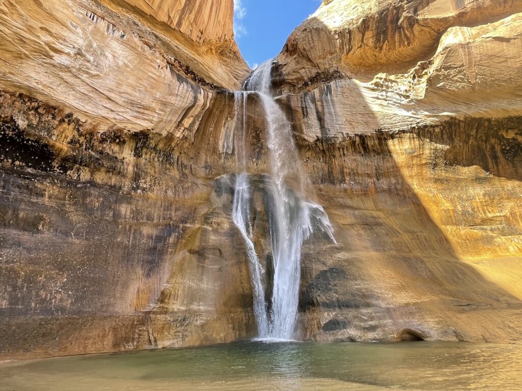
Things to Do in Southern Utah After Bad Weather
The small Kaibab Paiute Reservation was established in the early 1900s on the Arizona Strip, but it does not come close to encompassing the entire territory once roamed by the Kaibab Paiutes. While exploring northern Arizona, be cognizant of recreating responsibly in Paiute ancestral territory.
What is the Paiute Cave?


The Paiute Cave is an underground cave of volcanic rock located in the wilderness south of Colorado City, Arizona. It reminds me of the lava tubes at Snow Canyon State Park in Utah, which I explored with a headlamp alongside lots of families and children. I’m glad I did that hike last week, because it got my confidence up for cave exploration in a rather safe and populated environment.
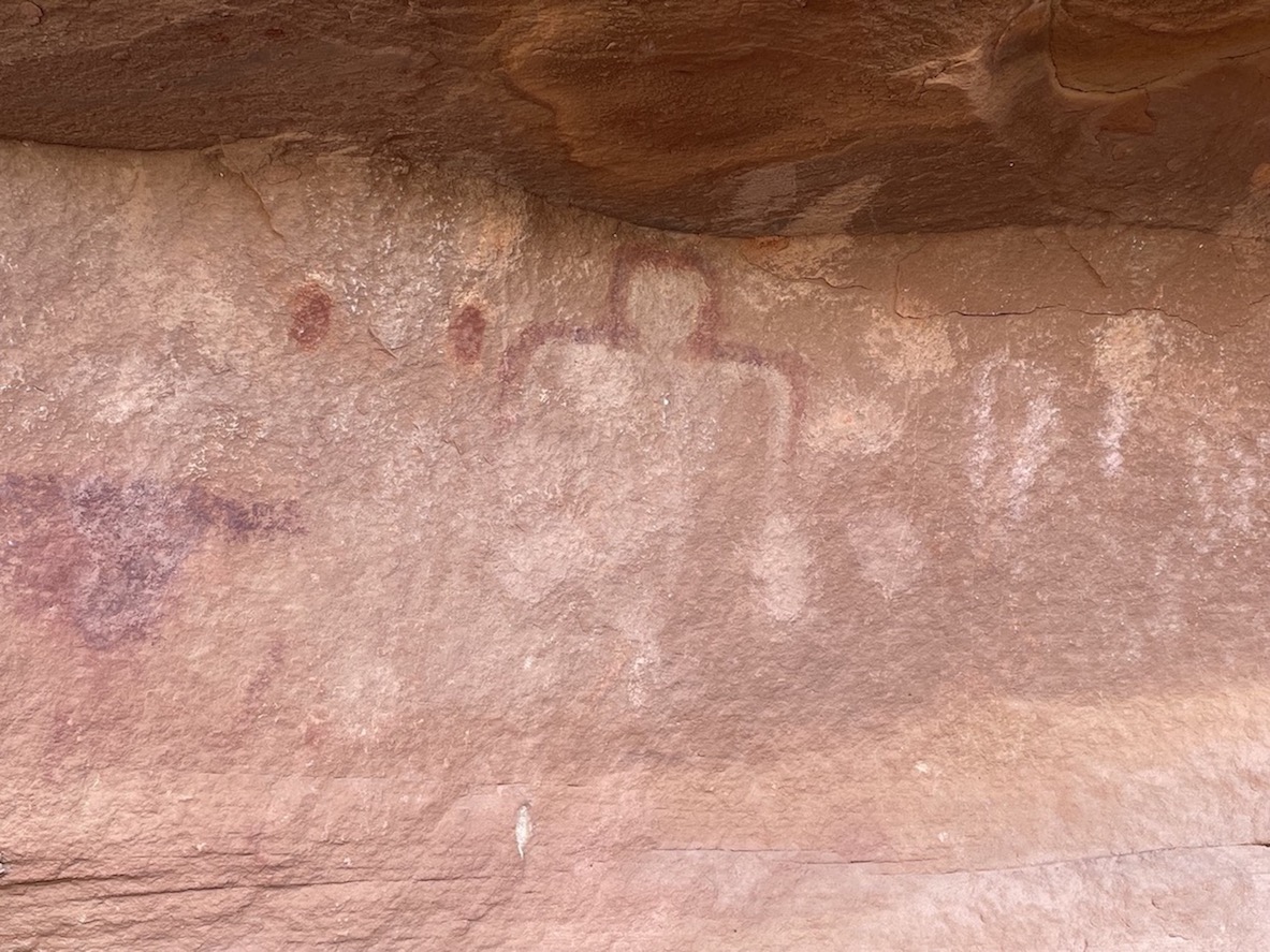
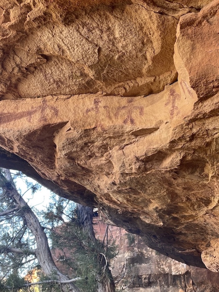
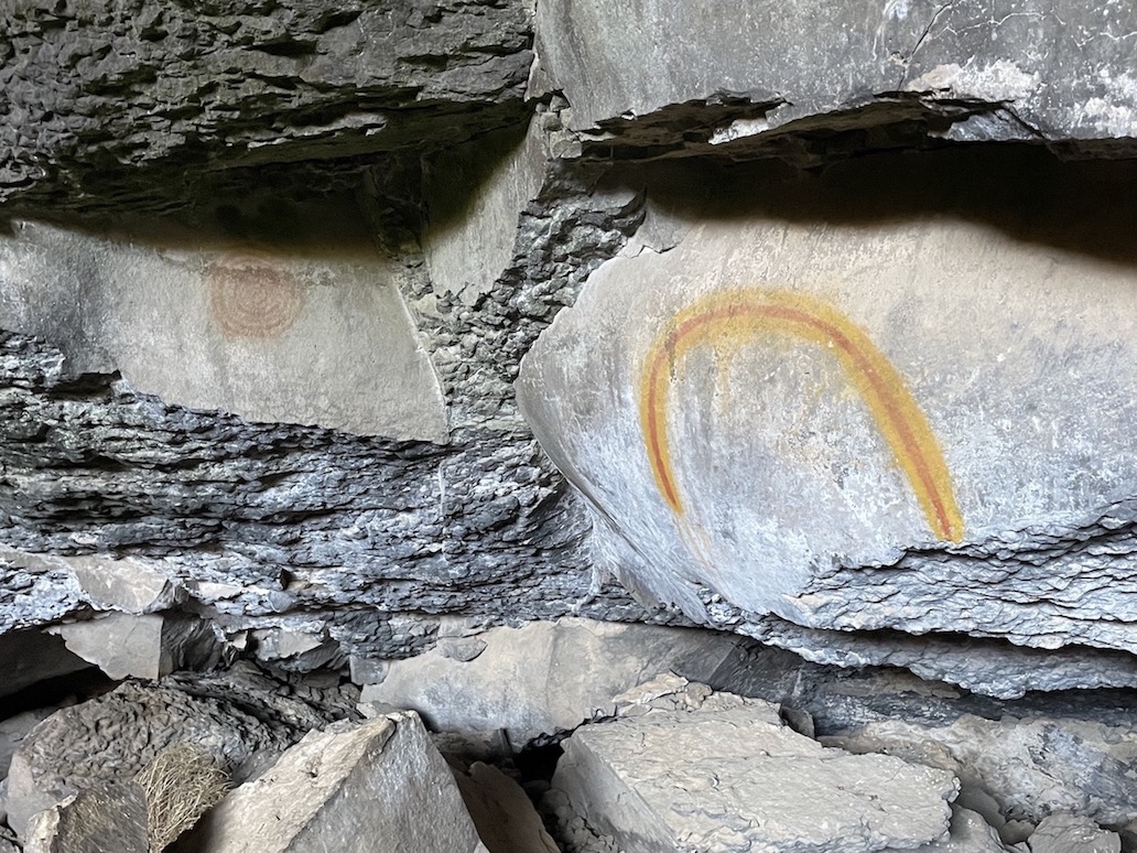
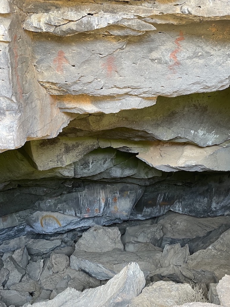
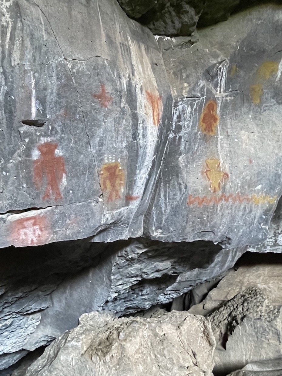
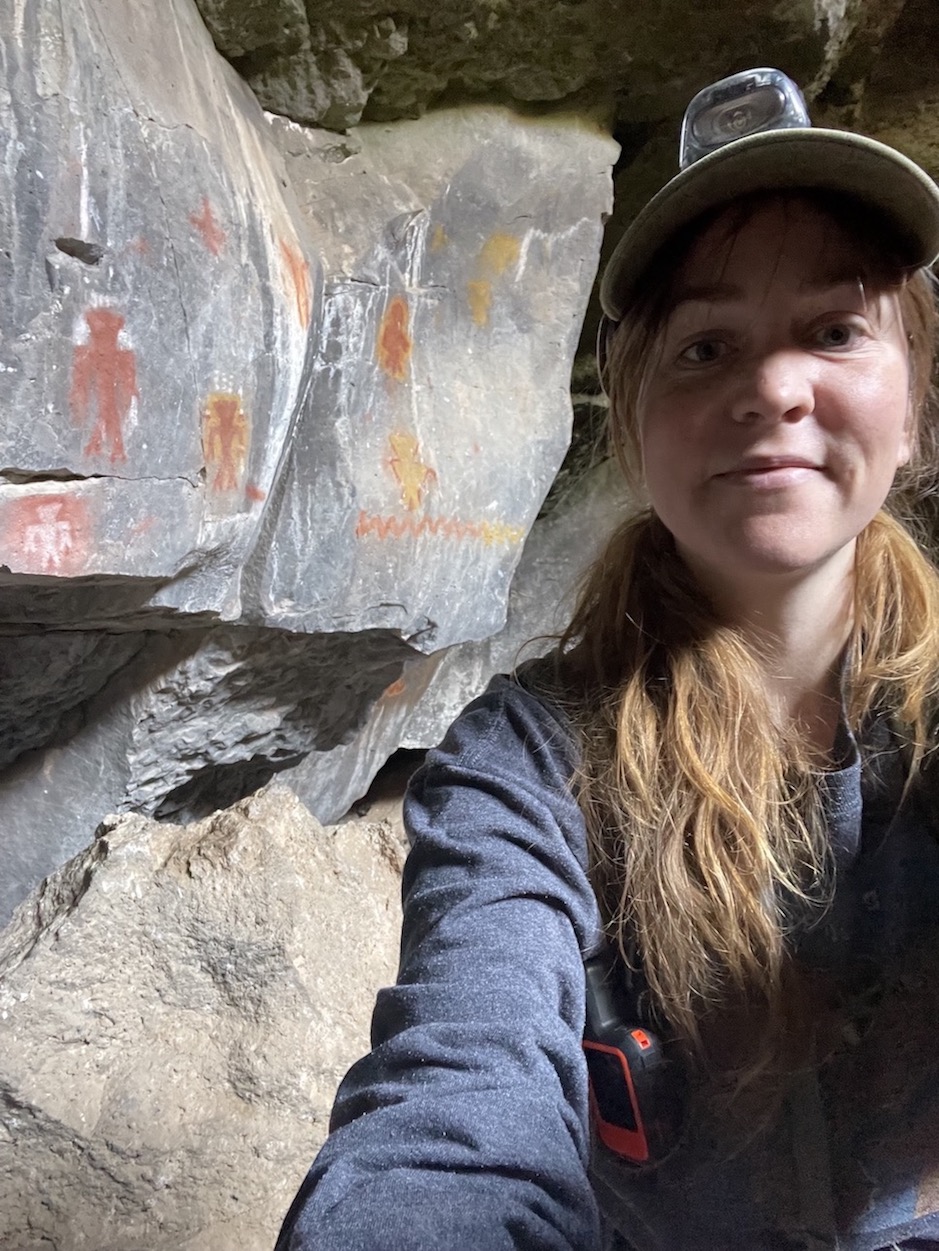
Inside the cave are very brightly painted pictographs of red and yellow! The Paiute Cave is the most vibrantly colored pictograph example I’ve ever seen with my own eyes. It’s shocking that the colors are so pristine, until you remember that the conditions of the cave environment played a hand in preserving the pictographs over hundreds of years. It’s very difficult for archaeologists to date pictographs and petroglyphs, so an exact timeframe is impossible to say.
When I have read about other rock art sites, one theory is that images like this were drawn or carved in places thought to be the origin of life, as if mankind had been birthed from this cave. A Bureau of Applied Research in Anthropology report called Ethnographic Assessment of Kaibab Paiute Cultural Resources In Grand Staircase-Escalante National Monument, Utah has a section on Kaibab Paiute creation stories, though, which doesn’t quite match up with this theory. It references Charleston Mountain or Buckskin Mountain as “origin” locations.
One story passed down about Ancestral Puebloan people says that they believed the Creator intended for them to wander the earth far and wide leaving many footprints, and if they did this, they’d inherit a promised land. In locations where they paused their travels and temporarily settled, you often find a symbol with a center point with swirling lines extending out from it in each direction. Perhaps they believed they had found “The Center Place”, although eventually they always moved on again, their journey to find the true Center Place continuing. You’ll notice in my Paiute Cave picture gallery that one symbol shows a swirl of concentric circles. Could they have had similar beliefs to the Ancestral Puebloans? The Puebloans were contemporaries of the Fremont culture, though, moreso than the Paiute.
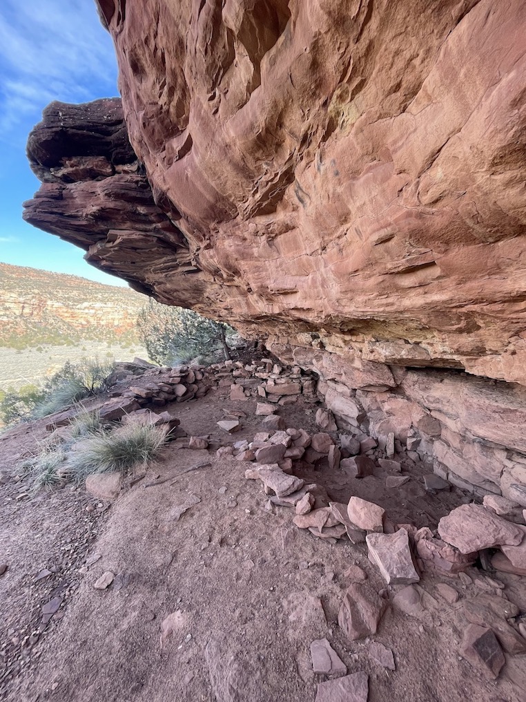
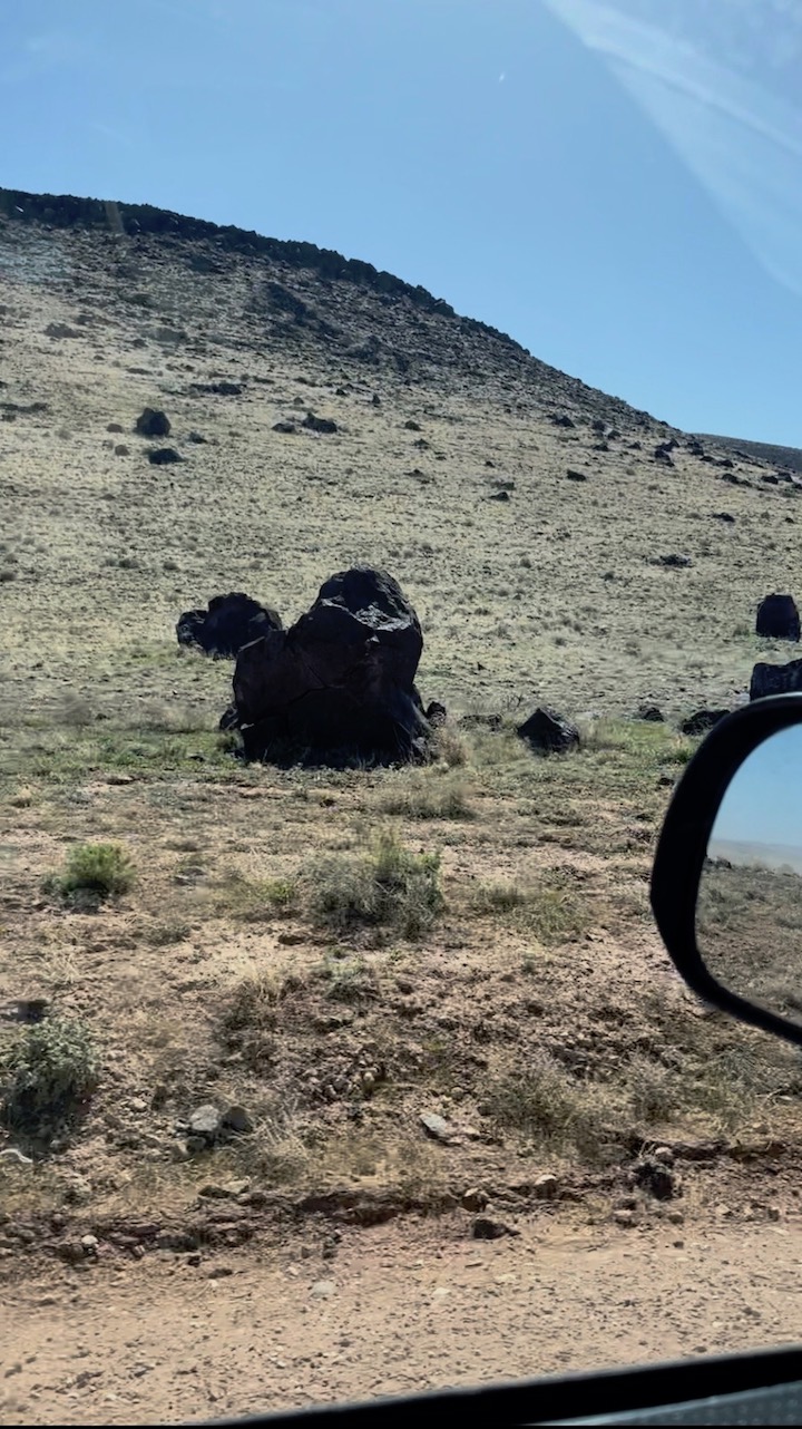
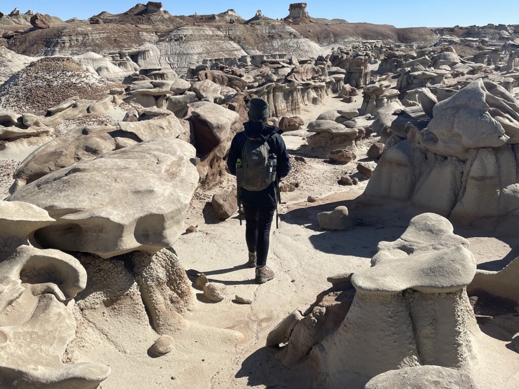
The Paiute Cave is in the middle of freaking nowhere, and if you weren’t looking for it, you could pass right by it without noticing it exists. The mouth of the cave isn’t gaping out of a mountainside, but is instead partially buried in the ground. The sparse brushy terrain nearly swallows it up completely.


Finding the Paiute Cave
Dos and Don’ts
The road to get to the Paiute Cave is entirely dirt with frequent variations between washboard, sand, and rocks. You do not want to embark on this journey after recent heavy rains, as the sand becomes deeply rutted clay. You do want four wheel drive, high clearance, a spare tire, a full tank of gas, an emergency communication device such as a Garmin InReach Mini, and an offline maps application like GAIA. You will lose cell service for most of the drive (although I was surprised to have it a bit longer than I expected in the beginning). It’s a lengthy drive if you heed the 35mph signs, so come prepared with music or pre-downloaded podcasts too. From the highway turnoff onto the dirt road it should take maybe an hour to reach the cave, though it felt much longer to me since I drove cautiously at the start.
It would not be a great idea to look for the pictographs in the dead of summer. If you have vehicle issues and get stranded, it will be brutally hot with no shade (except inside the cooler temperature cave, I suppose). Bring lots of water.
Trip Report
From the vague resources I found online, I hinged my navigation on a few landmarks: I would first turn off AZ-389 onto a dirt road, then cross a “wash”, then a volcanic boulder field, then there would be an old shack after which I should turn left, and then it’s 1.2 miles to the cave. I surmised which wash I was aiming for and set a waypoint on GAIA to let me know when I was nearing it. The first part of the drive to get to the wash took so long that I often wondered if I was on the right track, so having the waypoint to reference was a huge help for peace of mind. On the day of my adventure, the wash was thankfully bone dry. It’s not advisable to cross when wet.
After the wash, eventually I saw a building very far in the distance and wondered if this might be the “shack”. There was a road on my left leading to it, and I briefly worried that perhaps that was the left turn I was looking for. Then I remembered that I hadn’t crossed a volcanic boulder field yet, and my interpretation of the instructions was that the left turn would come after the shack, not lead to the shack. I kept pushing forward and voila, the next few landmarks came at me like rapid fire. Everything fell in line – I was upon the boulder field, then before I knew it, the shack appeared ahead on my right. The word “shack” was the perfect descriptor, and now I knew the previous building couldn’t have been it. Almost immediately the two track road on the left was apparent just after the shack.
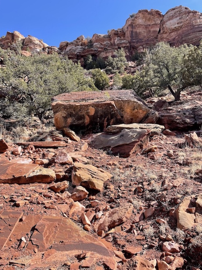
It should now be 1.2 miles to the cave. I ambled over and down a rocky hill and soon saw a short, flat-topped mesa on my left that I’d seen described in other accounts. This mesa is supposed to signal that you’re getting close to the cave. It didn’t feel like I had driven a mile yet, though, and I remember reading that there would be many groupings of volcanic rock at the foot of different mesas/hills to confuse my judgment as to which one marks the mouth of the cave. I hadn’t seen any other piles of rocks that looked significant, so I thought it was too early and I should press forward. I drove into rougher and rockier terrain and still didn’t see anything that looked right. Eventually I realized I must have driven past it, and around that time I noticed my InReach finally updated to tell me I’d driven 3.3 miles. Time to drive 2 miles backwards!
I figured the first mesa must have been the correct spot after all. I had seen tire tracks pulling off the road near it; clearly other people were stopping there. I retraced my route back to the mesa and pulled off where others had. This is when it became obvious that I’d found the cave. As you pull off to the side, the depression in the earth reveals itself opposite the mesa. I should have been looking to my right when I drove in the first time, instead of fixating on the base of the mesa on the left.
There is a metal box with a logbook inside, which I signed and dated with a sense of triumph. I saw that the last person to sign the book had visited four days prior. I strapped my headlamp on, though I would barely use it. The inside of the cave gets some sunlight. I carefully descended the haphazard piles of volcanic rock to lower myself into the ground. The brightest pictographs towards the bottom of the cave will catch your eye first, but don’t forget a few of them are painted along the upper and outer mouth of the cave as well.

A Little Detour
I was on cloud nine as I drove back towards civilization, thinking about how special it was to be able to commune with spirits of early Arizona history. As my thinking became more and more ethereal, I was abruptly pulled back to the here and now when I noticed a warning light flickering on my dashboard. My tire pressure was low. I hoped for the best but knew to brace for the worst; likely I’d punctured my tire on a rock when I drove on too far past the cave, or really it could have happened at any time at all throughout the entire drive. Popping a tire was a fear I’d had on my mind. I pulled over to inspect my tires and sure enough, the back right tire was audibly expelling air. At the moment it was still full enough, so I thought my best hope was to keep driving on it as far as I possibly could, hopefully back to cell service. I made it exactly to the place where the dirt road meets the highway and with some help from passersby I was able to get the spare on. Another one of my “detours”.
The flat tire was so rusted on that it was difficult to pry off by myself, which is why I was glad for the help. If I had succumbed to the flat at the cave, I wonder how soon someone would have come by. The logbook had said the previous visitor was four days ago. I could have used the SOS button on my InReach, so I would have been fine. I also could have walked back to the shack to flag someone down. While the whole journey felt very remote and “out there”, I surprisingly did pass a couple other cars. They didn’t turn left at the shack to get to the cave but instead were continuing forward, possibly heading to Toroweep Overlook, or maybe to a ranch. I saw plenty of cattle during the drive and at one point saw a cowboy riding a horse to round them up. So, if the fear of getting stuck is holding you back from searching the cave out, know that you are probably not as alone as you might feel and other cars are likely to pass if you’re doing this trip in a normal season with nice weather.
Imagining how the Kaibab Paiutes came to find the cave is an exercise of the imagination. The land is flat and desolate for miles around in every direction. I didn’t see any active water sources over the course of my drive, though my map seemed to show a few streams nearby. Are they as dry as the wash I drove through towards the beginning of my excursion? We know that there was a Great Drought just before 1300 AD that massively changed the landscape of the western United States. We also know there was the Little Ice Age between 1350-1880 AD, which brought more drought. Maybe there was more water here in the early days of the Kaibab Paiutes, between 1100-1300 AD.
Have you ever gone out of your way in search of archaeological sites? Trips like this make me feel like Indiana Jones. Or even better yet, have you stumbled onto a site like this on accident? What about getting stuck while off-roading looking for a place of interest? Sometimes it’s those unexpected moments that make a quest all the more exciting (as long as you find your way out of them!).
Related:


My dream is to write travel and hiking content full-time. All of my guides and itineraries are free and my travels are self-funded. If you enjoy my site and would like to support, you can donate any amount to my Ko-fi page. Thank you!!
I can’t believe how vivid these pictographs are! So cool! Also, very glad your truck made it to the dirt road and you were able to get help. Great idea to have your Garmin with you in case you needed to call for help.
This is awesome! I love pictographs and anything Paleolithic. Thanks for not making it easy for others to follow in your footsteps. Usually, if people are willing to “earn” one of these sites they’re more likely to respect them too! (Also, part of the fun is the hunt!)
Very cool that you got to have your own Indiana Jones moment on this adventure to find the Paiute Cave! It’s amazing how the pictographs remain so vibrant. Thank you for doing your part to protect the Native American rock art.
I love finding pictographs and petroglyphs out in the wild. However, I have never found any in a cave. This site looks incredible. Sorry about the flat tire, but it seems that you were up for the challenge.
Maybe there are more pictograph caves we don’t know about. Makes me wonder which settlers “discovered” the cave, and what they were doing down in there lol. It’s so out of the way.