

Zion Hikes to Do Instead of Angels Landing or Narrows
Purchases made through some links on this page may provide The Detour Effect with commissions (at no extra cost to you). Thank you!
The two most famous day hiking trails in Zion National Park in Utah, Angels Landing and the Narrows, are also the most crowded and the least advisable trails to hike during poor weather conditions. As a curmudgeon, I find myself asking why people even want to do these trails when there are plenty of rewarding and unique alternatives? Who told us they were the best, and why do we believe them?
Reasons Not to Hike Angels Landing or Narrows
Dangerous Conditions
Flash flooding can close the Virgin River Narrows slot canyon after springtime snowmelt or heavy monsoon rains in late summer, so you may not have a choice. As I write this, the Narrows is currently closed and the Park Service isn’t certain of a reopening date (this information will eventually become outdated; be sure to check current conditions). Contrastingly, when there hasn’t been a flood in awhile the new concern is cyanobacteria bloom, which is toxic to humans and animals.
Angels Landing is already precarious in the best of conditions, which is why chains were built into the ridgeline. This helps hikers steady themselves as they brave their way along the Landing’s spine with cliffside drops on both sides. In slippery, icy conditions, the chains might not be enough to assuage your fear of falling. On average, one person does fall every year.
Crowds
For me, an even bigger deterrent from hiking Angels Landing or the Narrows is the fact that these trails are extremely overcrowded. While the permit system is an attempt to solve this, the skinny Angels Landing path should really not be accommodating two-way traffic, and yet there is a constant assembly line of people headed in both directions.
In the Narrows, permits are only needed for the 16-mile top-down route and are not needed for an out-and-back day hike from Temple of Sinawava, so there is no capacity limit on day hikers.
Because so many people hear about the most famous trails, countless adventurous spirits attempt them despite barely having ever hiked a day in their lives. You might be sharing the Angels Landing chains with someone extremely inexperienced, and this is the type of trail where you want to be able to trust everyone around you.
Not the Most Scenic
Why do so many people make Angels Landing a bucket list item when it’s not even the best view in the park (and certainly not the best view in Utah), or much of a physical endurance test? It’s more of a psychological test, if anything. I have to imagine it’s strictly to be able to say they did it. Perhaps it’s a way to prove something, or maybe people are indoctrinated into thinking they want to complete the hike simply from hearing the name so often: Angels Landing, Angels Landing, Angels Landing….
Slot canyons are pretty dang cool (check out the slot canyon category on my site), but is the Narrows the prettiest slot canyon in the Southwest? It’s not the longest – that would be Buckskin Gulch. It’s not the most challenging, though perhaps that’s part of the draw; on the other hand it’s also not the easiest. Why does it stand out in people’s minds? Was there a marketing campaign?
If you’re like me, familiarity breeds contempt. Zion National Park is so vehemently overhyped that it was a letdown when I did finally drag myself on a visit. After having hiked in the Grand Canyon, Chiricahua National Monument, Capitol Reef, Bisti Badlands, the North Cascades, the Alps, the Scottish Highlands, MacGillycuddy’s Reeks, and more wilderness areas around the world, I find Zion to be quite…paved. It’s a very small park, a very developed park, and almost all of the day hiking trails accessible from the scenic road are made of concrete. Even the West Rim trail which leads to Angels Landing is paved up until the last second, where the Angels Landing spur splits off at Scout Lookout. Visiting Zion is a bit like visiting Six Flags.
If you decide you do want to experience the Narrows or Angels Landing but aren’t sure about solo hiking it, check out Wildland Trekking’s guided day hikes and multi-day tours.
Day Hikes to Do Instead of Angels Landing or the Narrows
Now that I’m done with my complaining, I must admit that if you’re looking to do something unique at Zion, interesting day hike alternatives to Angels Landing and the Narrows do exist. Ask yourself what your true motivations are and what you’re really trying to get out of a visit to Zion National Park, and you’ll find that there are many creative ways to achieve these goals!
Alternative to Angels Landing: West Rim Trail to Cabin Spring


Miles: However far you want to go; 10 miles out-and-back to Cabin Spring.
Trailhead: Starts from the #6 Grotto stop on the scenic road shuttle bus.
AllTrails
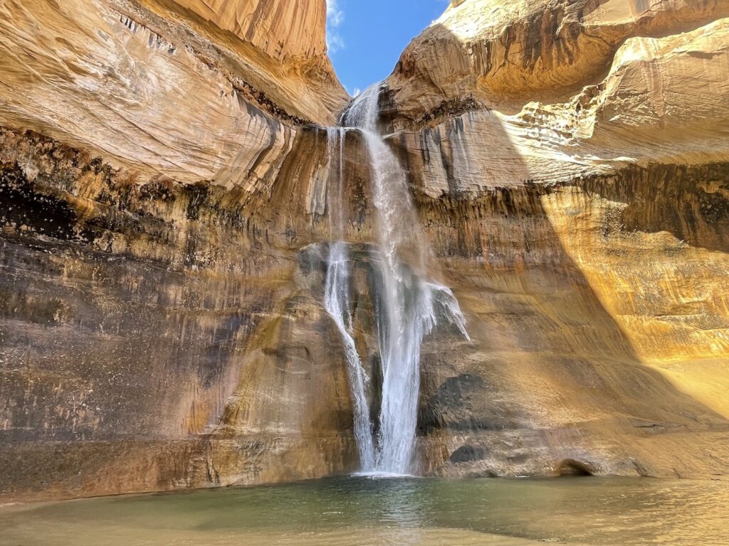
The West Rim Trail is the same trail you start on to reach Angels Landing. You’ll follow the hoards through the switchbacks of Walter’s Wiggles and up to Scout Lookout, where the spur to the Angels Landing chains begins. However, West Rim Trail continues on past Scout Lookout for many additional miles, and even becomes a long backpacking route for overnight trips. On a day hike, you can take the West Rim Trail as far as you like until you feel like retracing your steps back to the trailhead. Earn some bragging rights by crushing additional miles, or earn some of the best views in Zion National Park by continuing only slightly past Scout Lookout.
Stop and have lunch at the Lookout to watch the permit-holders ascend Angels Landing, but then leave them behind. Almost immediately upon turning your back, the crowds disappear and the views become more expansive. Within 15 minutes you’ll reach a vast slickrock plateau that sits much higher in elevation than Angels Landing, giving you a dazzling 360 perspective over the park. In the right conditions, a waterfall can be seen pouring over an adjacent cliff. If you continue on the West Rim Trail, you’ll horseshoe around to sit directly next to this waterfall. Many people turn back here, while backpackers continue onto the Horse Pasture Plateau towards Wildcat Canyon.
Alternative to the Narrows: Taylor Creek


Miles: 5 miles out-and-back.
Trailhead: You must park your vehicle at the Taylor Creek trailhead. Very accessible paved road.
AllTrails
If hiking in water was the enticing element of the Narrows for you, think about Taylor Creek instead. The Taylor Creek Trail is in the much quieter and cooler temperature Kolob Canyons area of northwestern Zion National Park. Kolob Canyons is not part of the scenic road serviced by the free shuttle bus that runs between the Zion Visitor Center and Temple of Sinawava. It’s necessary to drive to Kolob Canyons and park your vehicle at the trailhead.
This hike is a breath of fresh air, quite literally. While you’re likely to cross paths with plenty of other hikers, there should also be good stretches of time where you don’t see anyone else. There are so many creek crossings that I lost count, and my feet got soaked. Don’t plan on staying dry! Be sure to wear shoes that you don’t mind getting waterlogged, or perhaps think about bringing Chacos or Tevas to change into. I made good use of my trekking poles to help me across the creek as well.
Two historic 1930s-era homesteading cabins will greet you, including the Larson Cabin and Fife Cabin. Finally, you’ll reach your destination of the double arch alcove, a giant rock formation that drips with sheets of melting snow in the springtime.
Honorable Mentions
There are plenty of things to see in Zion National Park – I personally enjoy the Watchman Trail, for instance, and would include it on a “best day hikes in Zion” list – but alternatives to Angels Landing or the Narrows should feature similar selling points. The following trails are carved by water or have big views to scratch the same itch.
Many Pools Trail
The Many Pools Trail is on the East Rim of Zion National Park, just outside of the east entrance on the Zion-Mount Carmel Highway. If coming from Springdale, you’ll have to drive through the tunnel to reach this trailhead, and parking is very limited. This is a slickrock landscape similar to The Wave in the Vermilion Cliffs, Petrified Dunes in Snow Canyon State Park, or the last portion of Cassidy Arch trail in Capitol Reef. This means there’s not really a set “trail” you must follow, though you may see faint hints of where most people tend to walk. You’ll just traverse a wide expanse of rock that provides a strange and beautiful lesson on the forces of geology and weathering over millennia. Potholes cache rainwater and make your photos pop.
Observation Point
If you’re prioritizing views, Observation Point provides a phenomenal one. Unfortunately the classic trail to Observation Point via East Rim Trail (the #7 Weeping Rock scenic road shuttle stop) has been closed for years due to rock fall, but you can still access it via East Mesa Trail instead. Driving to this trailhead on the rough road is the most challenging part of the trip, and it may not be accessible in winter or after heavy rains. East Zion Adventures offers a shuttle if your car isn’t four wheel drive and high clearance. East Zion Adventures also offer all kinds of interesting guided day tours.
🏨 I wrote about free places to car camp near Zion National Park in my Utah digital nomad guide here. If you prefer a roof over your head, find budget hostels near Zion National Park here, and standard hotel options here.
✈️ Coming to Utah from further afield? Use an Airalo eSIM for affordable international cell data and don’t forget to protect your investment with travel insurance.
Whether of your own volition because you simply don’t feel drawn to and inspired by the same trails as other hikers, or by force because Mother Nature has other plans, sometimes a second-choice trail can really turn out to be the main event. In other words, the detours are often better than the advertised itineraries. If you’re looking for bad weather alternatives to popular trails throughout other areas of Southern Utah like Grand Staircase-Escalante, Snow Canyon, or Capitol Reef, check out this post:
Things to Do in Southern Utah After Bad Weather
Pin It:

Related:


My dream is to write travel and hiking content full-time. All of my guides and itineraries are free and my travels are self-funded. If you enjoy my site and would like to support, you can donate any amount to my Ko-fi page. Thank you!!
Thank you so much for this! The Taylor Creek trail was our favorite hike in Zion (so much so that my husband was lobbying to do it a second time), and I doubt that we would have done it without this guide. We decided to go up to Cedar Breaks instead, and hike the rim trail which was another great option (not as showy as Bryce, but the relative solitude made up for it). Keep up the great work — it’s nice to hear from someone not pushing us to do the Narrows or Angel’s Landing as so many other travel writers do.
Yay, thanks Christina, I really appreciate you dropping by to tell me how it went for you guys! I’m excited that you enjoyed it so much, and validated that you agree about those other more popular trails haha, it gets tiring hearing about them. They are really not obligatory. Sounds like you guys got creative and followed your heart for your Utah itinerary. I’ve never been to Cedar Breaks!
In planning a month tour through various NPs in the west, I happened upon your site while researching Yellowstone. I like your approach, and am clicking affiliate links where I can. I hear you on the overcrowded and paved nature of Zion. That said, I did manage to do Angels in a way that I didn’t hate.
1. Get lucky for the first AM lottery time slot (or stay in the park)
2. Get in the bus line for an hour, ride the first bus
3. Hightail it to enjoy about 5 minutes of solitude before the masses encroach
… then it was West Rim up to about Goose Creek Knoll. Views for days!
Watchman was great, and if you haven’t done it I definitely recommend Mount Kinesava. Plenty of solitude, and a tough / rewarding choose-your-adventure hike. The Northgate Peaks also had stellar views and just a smattering of hikers.
I see you made it to the “end” of Taylor Creek under the massive rock overhang! That was one of my favorites.
Oh awesome, I’m glad it worked out and was fun! Sounds like that early permit time makes all the difference, good job beating the crowds. I haven’t done Kinesava or Northgate Peaks, thanks for the recs; I’ve been thinking I’m due for another Utah trip. So much else I still wanted to do in Capitol Reef, Canyonlands, Fishlake NF, Dixie NF, Henry Mountains etc.
Where else are you headed on your month-long trip? Sounds like an adventure. Thanks so much re: my Yellowstone post and for the support with the links, I hope the site’s been useful!
I know, Utah is a gem! So many things to do. I’ve not been to all the places you mention; my to-do list is growing. Down by St. George I’d also recommend Snow Canyon State Park and Pine Valley Mountain Wilderness.
The upcoming trip is going to be fairly aggressive with 8 NPs: Grand Teton > Yellowstone > Crater Lake > Lassen Volcanic > Yosemite > Sequoia > Death Valley > Great Basin
re: support – absolutely, it’s easy to tell you’ve really done the things you write about and that authenticity is appreciated.