
Hikes and Treks for Travelers Who Love Archaeology
Purchases made through some links on this page may provide The Detour Effect with commissions (at no extra cost to you). Thank you!
All hikers have their own motivations when it comes to choosing which trails to complete. Some may look forward to big, sweeping views. Others like secluded swimming holes, peakbagging, wildlife watching, or chasing waterfalls. Personally, my favorite trails feature some kind of ancient archaeology.
I’ve never studied archaeology, although I wish I had. Perhaps travel and hiking are the best methods of hands-on learning, anyway. When I visit cities on my travels, I always prioritize archaeology museums like the National Museum in Dublin, the National Museum in Copenhagen, the State History Museum in Bishkek, or the Museum of Native American History in Bentonville, Arkansas. When I embark on a road trip, I stop to see petroglyphs, pictographs, pueblos, and cliff dwellings, and love hunting for them in unmapped places.
After hiking ten long-distance trails around the world and enjoying countless day hikes at home and abroad, I’ve noticed a pattern that the routes I list as my favorites usually have special archaeological significance. This post aims to share what I’ve learned about these interesting monuments during my travels and, if you have a special interest in human history too, help you choose your next hiking trail.
I’ll only be including hikes located in countries that I have personally visited; obviously there are many, many more archaeological examples that can be found on hiking trails all around the world!
How do hiking, archaeology, and anthropology relate?

Hiking is an underrated way to learn about how a travel destination’s culture developed because it forces you to interact with the elements that influenced local people for centuries. What plant, animal, and geological resources did native people have available to them, and how did this determine the way they built their homes, the clothes they wore, the games they played, the way they buried their dead, their folklore, and the recipes they developed? What sort of choices did they make based on terrain conditions like hills, flat prairies, wind, bogs, or desert? At times, the landscapes I’ve gotten to experience through hiking have even given me a greater understanding of a people’s spiritual beliefs and ritualistic practices.
The histories you’ve read about in books or artifacts you’ve seen in museums start to make a lot of sense when you’re physically placed in the relevant setting, fighting for your life while wading across a swamp, scrambling over rocks, taking shelter from a storm, or hearing mysterious sounds go bump in the night.
The Kerry Way, Ireland: Ogham stones and wedge tombs


The Kerry Way is a 9-day thru-hike along the Ring of Kerry on the southwest coast of Ireland. When I set out to complete this trek I hadn’t done too much research in advance, so I was pleasantly surprised to stumble upon a wedge tomb and Ogham stone in between Waterville and Caherdaniel.
A wedge tomb is an early Irish Bronze Age above-ground structure with large stone slabs placed upright to create three walls and a roof. They are usually tallest at the front where the opening is. Human remains inside could either be skeletal or cremated.
“Wedge tombs seem to be a specifically Irish type of monument and are generally thought to be the youngest of our Stone Age monuments, dating from the cusp of the Neolithic and the Bronze Age.”
Carrowkeel.com
Ogham stones are large upright stones into which letters of the Ogham alphabet were carved, almost like runestones. According to Megalithic Ireland, “Ogham is the earliest form of writing in Ireland; it dates to around the 4th century AD and was in use for around 500 years.” It is “a uniquely three-dimensional script” because it was written vertically along the edges of the rock rather than on the smooth rock face. The meaning of the carved lines depends on their position relative to the rock’s edge. About 400 of them survive today; many are on display in the “Stone Corridor” at University College Cork, but a few, like the one you can see along the Kerry Way, remain in their original natural environment.
There’s also a stone circle in Kenmare, though you need to seek it out as it’s not directly on the trail, and of course if the weather is good you could take a ferry to the ancient UNESCO monastery at Skellig Michael.

Free Download | The Kerry Way: Self-Guided
Wicklow Way, Ireland: Glendalough monastic site


Ireland has a lot to offer for archaeology enthusiasts! On the Wicklow Way, a 6+ day thru-hike, hikers eventually reach Wicklow Mountains National Park and the monastic city of Glendalough. A cemetery, round tower, church, and the ruins of a cathedral are main attractions. Tour groups can also visit from Dublin, but hikers have the satisfaction of knowing they’ve properly pilgrimaged to the site as travelers on foot have done for centuries. There is also a shorter pilgrim path to reach Glendalough called Saint Kevin’s Way.
St. Kevin founded the monastic settlement at Glendalough in the 6th century AD, though most of the buildings still standing are from the 10-12th centuries. Glendalough persisted through sieges by Vikings and Normans, rebuilding time and time again. Artifacts found at Glendalough can be viewed at the National Museum of Ireland – Archaeology in Dublin.

Guide to Camping the Wicklow Way in Ireland
Hadrian’s Wall, England: Roman border wall


Hadrian’s Wall is a thru-hike across England that can be completed in 6+ days; I recommend taking longer than 6 days so you can properly explore all of the incredible Roman ruins, museums, and archaeological sites, particularly in the middle section of the trail.
Hadrian was a Roman emperor from 117–138 AD who is famous for building a wall to protect the northern border of England from those primitive heathens in Scotland. The wall included milecastles and turrets where soldiers were stationed to keep watch, and you can still observe the square foundations of many of them today. Roman settlements grew around the wall, such as the one being excavated at Vindolanda Roman Fort.
Vindolanda is a must-visit museum for hikers. I would also recommend setting time aside to visit Housesteads Roman Fort, Birdoswald Roman Fort, Chesters Roman Fort, and/or Carlisle Castle.

Cost Breakdown: Solo Hiking Hadrian’s Wall [2023]
Arctic Circle Trail, Greenland: Hunting ground cairn and Inuit nomad camp


The Arctic Circle Trail in Greenland, an 8+ day thru-hike, is so remote that I didn’t expect to find much evidence of human history. I was pleasantly surprised to learn that it actually intersects with a UNESCO property called Aasivissuit – Nipisat, which migratory hunters have visited for 4,200 years.
Most of the cairns on the ACT are modern, but one stands out as being particularly old – you’ll know it when you see it.
If you take the bridge detour instead of crossing the river halfway through the trek, you’ll come upon Itinnerup Tupersuai near the head of the Maligiaq fjord. This ancient Inuit nomad camp is still in use today as a temporary base in spring and summer when the char fishing is at its best. Originally people would have paddled up the river by qajaq (kayak) or umiaq, but today they would use motorized boats, or dog sleds or snowmobiles in the winter.

Arctic Circle Trail History, Tips, Context – That Aren’t About Hiking!
Snowdonia National Park, Wales: Bronze Age stone circles


I didn’t do any multi-day hikes in Snowdonia, but I enjoyed day hikes up Snowdon, to the Castle of the Wind and Cantilever Stone, and to the “Druid Circle” near Conwy.
The Bronze Age stone circle above the town of Dwygyfylchi in the Carneddau region of Snowdonia National Park probably has nothing to do with druids (although nearby Anglesey island certainly does), but this doesn’t reduce how mystical the site feels. It sits atop sweeping grasslands dotted with wild ponies, gracing visitors with views of rolling hills in one direction and the ocean in the other. It’s easy to imagine why this location might have been picked out to serve as some sort of ceremonial site.
There are actually multiple stone circles all near each other on the hiking trail I described in my dedicated post about the area. You can also continue hiking all the way down into Conwy to visit Conwy Castle, constructed by Edward I in the 13th century.

Hike to a Bronze Age Stone Circle in North Wales
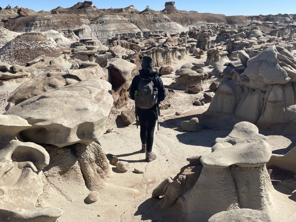
Chaco Canyon National Park, New Mexico: Pueblo ruins, pictographs, and petroglyphs


Chaco Canyon is one of the coolest national parks I’ve ever been to in the United States, but it seems particularly undervisited. It does require a long drive on bumpy roads, but what a reward you’ll earn for making the effort!
Chaco was built by Ancestral Puebloan people between 800-1150 AD and was ultimately abandoned, much like other Ancestral Puebloan sites throughout the Four Corners. During its time it was an important trading and ceremonial center; in the Southwest, all roads led to Chaco rather than Rome.
The biggest pueblo structures, like Pueblo Bonita, can be easily viewed on a leisurely walk. It’s almost like an outdoor museum. You can explore the inside of some structures, wander the plazas, and imagine yourself living there hundreds of years ago.
Day hikers are in luck, because there are additional ruins and rock art carvings that can be seen on longer trails. These include Tsin Kletsin (3 miles out-and-back or 4 miles as a loop), Pueblo Alto (5.4 mile loop), and Peñasco Blanco (7 miles out-and-back). These ruins are hidden away atop mesas that are difficult to see from below; their inhabitants must have wanted to stay unnoticed by the frequent travelers and traders visiting Chaco Canyon. Less reconstruction has been done on these sites and when I was there, I didn’t see any other hikers, so nothing “takes you out of it.” Admiring their handiwork in this untouched landscape can feel quite spiritual.
In my post about Chaco Canyon and other interesting Ancestral Puebloan sites in northern New Mexico, I wrote more about where to find petroglyphs and pictographs. My favorite is the supernova pictograph, a handprint next to half moon and sun shapes.
Northern New Mexico Road Trip: Bisti Badlands, Ancestral Ruins
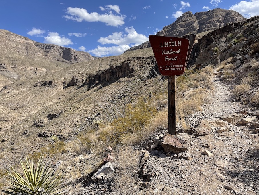
Organ Mountains, New Mexico: Prehistoric cave


There may be fewer Ancestral Puebloan sites outside of the Four Corners region, but southern New Mexico is not to be overlooked as an archaeology hotspot! The Dripping Springs Natural Area on the west side of the Organ Mountains near Las Cruces features a bunch of cool day hiking trails, but I’m particularly intrigued by the one that leads to La Cueva. This natural cave beneath a rock overhang was used as a shelter by the Jornada Mogollon as early as 5000 BC.
More recently in the 1860s, an Italian ascetic hermit named Giovanni Maria Agostini walked into New Mexico and took up residence in the cave. He was later murdered there, the crime still unsolved to this day. Read more about his story in my “Historical Adventurers Whose Lives Deserve Movie Adaptations” post.
A series of other strange Wild West murders happened near Las Cruces only a few decades later in association with a man named Oliver Lee. Today, Frenchy’s Cabin in Oliver Lee Memorial State Park, where Francois-Jean Rochas lived and died, can be hiked to via the Dog Canyon Trail.
Best Hikes Near Las Cruces, New Mexico
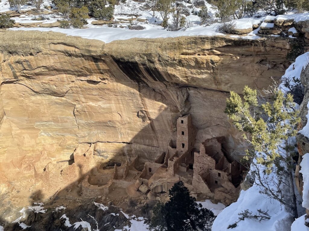
Mesa Verde National Park, Colorado: Cliff dwellings


The cliff dwellings, pueblos, and pit houses in Mesa Verde National Park in Colorado were built by Ancestral Puebloans between 550-1300 AD, after which Mesa Verde was abandoned as people migrated away and joined neighboring groups.
Cliff dwellings were built into the side of canyon walls, often protected by a rocky overhang. I have also visited cliff dwellings in Arizona at Walnut Canyon and Montezuma Castle, and I know there are some at Bears Ears and elsewhere in Utah (some requiring pretty adventurous bushwack-style hiking), but at Mesa Verde they are numerous and on a whole other level as an architectural feat. Particularly impressive are Cliff Palace and Square Tower House.
People don’t think of Mesa Verde as a hiking park as much as a cultural park, but you can actually do some cool hikes for better vantage points! In wintertime, snowshoeing is the only way to visit some pueblos such as the Far View Sites. In summer, the Petroglyph Point Trail is very challenging and leads to a panel of rock art.
Things to Do in Mesa Verde National Park in Winter
West Highland Way, Scotland: Abandoned ruins


The West Highland Way has produced one of the great mysteries of my hiking career. While completing this 96-mile thru-hike, I came across the mossy ruins of abandoned homes being reclaimed by nature in Scotland’s forests and highlands. After the hike I desperately tried to research what they were, but I never found any information about some of them. A few are identifiable, such as Tigh-na-Sleubhaich, but others seem to exist only in my memory.
As you hike, informational signs will explain the local history associated with Robert the Bruce, the Jacobite Rebellion, and the Glencoe Massacre.

Cost Breakdown: Solo Hiking the West Highland Way [2023]
Big Bend National Park, Texas: Petroglyphs and pictographs


My favorite hike in Big Bend National Park for big views is the South Rim Loop, but the coolest one for archaeology is the Chimneys Trail. Over the course of 4.6 miles out-and-back, you’ll traverse a flat expanse of desert with absolutely no shade until you reach a tall rock randomly jutting up out of the earth. The trail takes you briefly up the side of this strange mesa-esque formation until you find an awesome panel of petroglyphs making difficult-to-decipher shapes that don’t look much like those I’ve seen in other states. The National Park Service says the oldest glyphs are several thousand years old.
Rock art can also be found in Big Bend Ranch State Park, but to reach them you would drive a 4WD vehicle on a rough road instead of hiking. Near Terlingua, the Indian Head trail will bring you to petroglyphs, though they were vandalized by dipshits in 2022.
Read about other Native American archaeological sites in West Texas in my articles about day hiking and nomading in Big Bend. While hiking in Big Bend, do me a favor and keep an eye out for evidence of Spanish explorers so you can help me solve the mystery of Cabeza de Vaca.

Best Moderate Difficulty Day Hikes in Big Bend National Park
Canyonlands National Park, Utah: Pictographs


Barrier Canyon-style pictographs and petroglyphs are very distinctive both in origin and style. While most of the rock art I’ve seen in Arizona and Utah is attributed to the Fremont or Ancestral Puebloan cultures and dates to 1100 – 1300 AD or later, the anthropomorphic characters drawn in Canyonlands National Park may clock in at 2000 BC – 500 AD or even earlier. Clay figures discovered close by date back 7,000 years!
A 7-mile out-and-back day hike is required to reach these remote pictographs in Horseshoe Canyon. A long, very bumpy drive will bring you to the trailhead.

Photo Gallery: Barrier Canyon Style Pictographs
The Jordan Trail, Jordan: Rock-carved architecture and petroglyphs


I have yet to thru-hike the multi-day Jordan Trail, but I did do a small section by hiking the Back Trail to the Monastery at Petra and a guide took me into a slot canyon to look at petroglyphs in the Wadi Rum desert.
You don’t have to hike to enjoy the incredible carved city of Petra – though you do have to do a lot of walking! However, instead of walking in from the direction of the Siq and Treasury, hiking the quieter Back Trail to reach the Monastery brings you along an old Bedouin path that perhaps the Nabataeans (who built Petra in the 3rd century BC) themselves would have taken. I doubt I need to explain the spectacular significance of what you’ll see once you enter Petra, one of the most jaw-dropping UNESCO World Heritage Sites and ancient architectural achievements in the entire world.
In Wadi Rum, I was delighted to discover that Jordanian rock art carvings look incredibly similar to the ones I’ve seen in Arizona and Utah. In my post about unexpected things I learned in Jordan, I compared pictures of them side-by-side.

Ten Unexpected Things I Learned In Jordan
Issyk-Kul, Kyrgyzstan: Petroglyphs


During my trip to Kyrgyzstan, I got to hike near Karakol and ride horses at Son Kul Lake, and though I visited Issyk-Kul Lake, I didn’t see the petroglyphs in this region. I did see petroglyphs from Issyk-Kul when I was at the State History Museum in Bishkek, and I saw reproductions of petroglyphs sewn onto handbags at a tourist shop, but I didn’t get to hike to see them in their original environment.
Rock art sites can be reached from Cholpon Ata via various day hike routes that shouldn’t take more than a couple of hours. If you plan on being in a different region of Kyrgyzstan, check out Visit Kyrgz’ list of petroglyph sites around the country.

The Best Part of My Kyrgyzstan Trip – Don’t Skip Son Kul Lake
Orastie Mountains, Romania: Dacian fortresses and stone circles
One place that really captured my imagination in Romania is Parcul Natural Grădiştea Muncelului Cioclovina, the mountainous area above the town of Orăștie. Here, there are five pre-Roman ruin sites attributed to the native Dacians. A sixth Dacian ruin is located in between Sibiu and Orăștie.
These six UNESCO-recognized sites are collectively referred to as the Dacian Fortresses, though some of the pictures look more Stonehenge-like than fortress-like. Built in the 1st century BC – 1st century AD, they probably served a dual religious and militaristic purpose. They were conquered by Romans in the 2nd century AD.
I was not able to figure out a way to easily reach them by public transportation from Brașov and the guided tours I found were private-only, which is too expensive for me as a solo traveler. To reach them you’ll need to rent a car or pay for taxi rides that may not get you all the way to each site depending on how rough the roads are. I found a great forum where hikers describe hiking in to see some of the fortresses, or sometimes taking a bus or car half of the way and hiking the rest.

From Brasov Without a Car: Day Trips and Weekend Trips in Romania
As you can tell by the archaeological sites I chose to include, I am most excited by prehistory. Of course, archaeology can refer to any time period. If I were to include mining ghost towns in Colorado or WWI- and WWII-related locations throughout Europe, for instance, I could expand this list with dozens of additional trails. What’s your favorite era of history to investigate through the medium of archaeology? Can a hiking trail take you there?
When I’m hiking trails with evidence of the past, it’s as if a portal has been opened and I’m able to imagine the person I might have been had I lived in that time and place. Think of the many lives you could have lived if only you were born under different circumstances and in different geography. Which version of you do you like the best – the Highlander? The Puebloan? The monk? The Roman centurion?
Pin It:


My dream is to write travel and hiking content full-time. All of my guides and itineraries are free and my travels are self-funded. If you enjoy my site and would like to support, you can donate any amount to my Ko-fi page. Thank you!!